Monthly Archives: June 2014

Journeys in Space: An Excellent Motorcycle Adventure! Day 8!

An Excellent Motorcycle Adventure!  Day 8!

There and back again... Sheridan WY to Dayton WY to Sheridan WY

There and back again… Sheridan WY to Dayton WY to Sheridan WY

More to Come! 

  • A long day, but a short trip, to Dayton WY
  • More discussion of the Quotidian at the Rustic Campground
  • A return to Sheridan WY

Summary
Date:  June 23, 2014
Departure Location:  980 Sibley Circle Sheridan, WY
Arrival Location:  612 N Main St   Sheridan, WY
Total Miles:  45.2
Total travel time: 7:25
Total miles/total travel time: 6 mph
Number of States:  1 (Wyoming)
Number of Watersheds:  1 (Mississippi River… Missouri River Division)
Stops:  2 (Ranchester WY (wind delay),  Dayton WY (coffee, wind delay, cribbage))
Weather:  Sunny, WINDY AM, Sunny WINDY PM
Temperature:  7:00 AM (Sheridan WY) 68 ͦ  F, 12:00 Noon (Dayton WY) 76 ͦ  F, 7:00 PM (Sheridan WY) 66 ͦ  F
Lodging:  Best Western Sheridan Center, Sheridan WY
Restaurants:  Crazy Woman’s Saloon Dayton WY, Wyoming Rib and Chop House Sheridan WY

5 Comments

Filed under Journeys in Space

Journeys in Space: An Excellent Motorcycle Adventure! Day 7!

An Excellent Motorcycle Adventure!  Day 7!

Rapid City SD to Sheridan WY with a quick stop at Dewey's Place in Moorcroft WY

Rapid City SD to Sheridan WY with a quick stop at Dewey’s Place in Moorcroft WY

More to Come!

  • A visit to Mount Rushmore…
  • Wyoming ranches and mines…  a discussion of the Quotidian
  • A restaurant review of Dewey’s Place in Moorcroft WY
  • Another Glimpse of the Sublime
  • The Hampton Inn, Sheridan WY… the medium security prison of IHLCs

Summary
Date:  June 29, 2014
Departure Location:  523 6th St. Rapid City, SD
Arrival Location:  980 Sibley Circle Sheridan, WY
Total Miles:  272
Total travel time: 9:27
Total miles/total travel time: 28 mph
Number of States:  2 (South Dakota, Wyoming)
Number of Watersheds:  1 (Mississippi River… Missouri River Division)
Stops:  3 (Rapid City SD (gas), Mount Rushmore (sightseeing), Moorcroft WY (lunch))
Weather:  Sunny AM, Sunny PM
Temperature:  7:00 AM (Rapid City) 72 ͦ  F, 12:00 Noon (New Castle WY) 76 ͦ  F, 7:00 PM (Sheridan WY) 76 ͦ  F
Lodging:  Hampton Inn, Sheridan WY
Restaurants:  Dewey’s Place Moorcroft WY, Wyoming Rib and Chop House Sheridan WY

2 Comments

Filed under Journeys in Space

Journeys in Space: An Excellent Motorcycle Adventure! Day 6!

An Excellent Motorcycle Adventure!  Day 6!

A giant low pressure system has caused us to detour west and south.

A giant low pressure weather system in Canada system has caused us to detour west and south.

An Excellent Motorcycle Adventure!  Day 6!

Dealing with Weather…

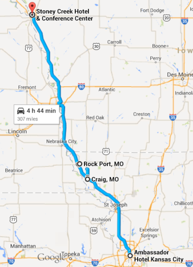
Given Day 5 problems with the weather, we are extra vigilant at the start of day 6.  We set the alarm[1] for 5:00 AM and immediately log into our ASTT devices and turn on the Weather Channel.  The meteorologists explain not only what happened to us yesterday but what is likely to happen to us today.

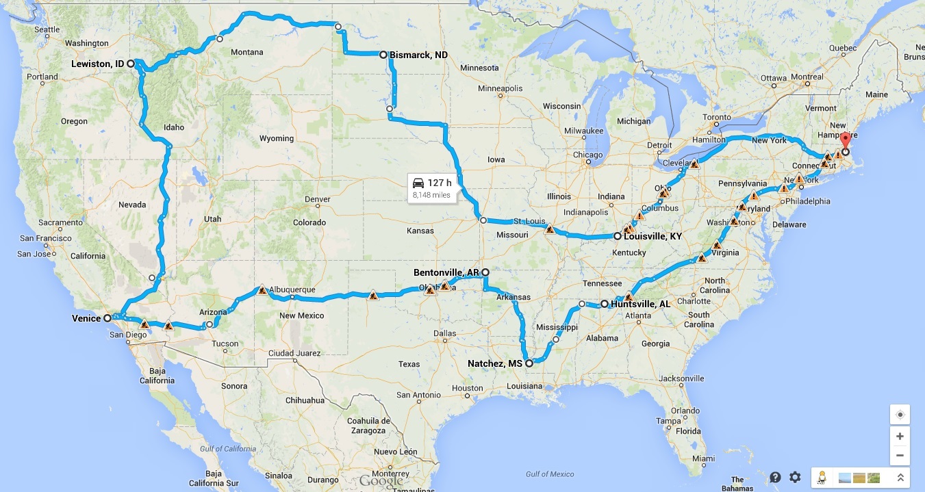
There is a HUGE low pressure weather system in northern North Dakota and southern Canada, centered over Winnipeg, Manitoba.  It has stalled on its eastward progress, slowly drifting along the Canadian border at only a few miles an hour.  It is a powerful storm system that is dominating the weather in the center part of the country.  The counterclockwise flow of the system is drawing huge amounts of moisture up from the Gulf of Mexico and triggering thunderstorms in a line stretching from Louisiana, through Sioux City (our current location) and up through Pierre SD, Bismarck ND and into Canada (which is our planned travel route for the next two days).  We have planned 736 miles of travel over the next two days, finishing in Williston ND[2], but given that Day 6 and Day 7 weather forecasts look like a repeat of Day 5 we are concerned about our ability to cover this distance.  We made only 30 mph yesterday[3], so the planned 736 miles of travel could easily take three or even four days if the weather stays bad…. and there is every indication that it will stay bad.

So it is time to make a decision.  Do we preserve our route and spend a couple of more days on the road on our westward journey?  Or do we alter the route and take a more southerly route… giving up on Northern Montana… but that gets us to some schedule obligations that we have in California the second week of July?

We discuss all the ins and outs of this decision and finally we decide that fighting rainstorms for the next two or three days is not anyone’s idea of fun.  We reroute our trip to head today for Rapid City South Dakota.  In particular, we are going to try to head west as soon as we can today to avoid the immediate threat of rain in Sioux Falls SD, our planned route.  Our route today will be predominately westerly.  It is likely we will dodging isolated rain showers the whole day, but we should be able to make decent time.  Our endpoint in Rapid City puts us just about as far west as Williston ND… so we are effectively saving a day in our trip west[4].

All this is accomplished before 6:30 AM.  We pack and head down to the “free” breakfast buffet offered by the hotel[5].  We are on the road before 8:00 AM.


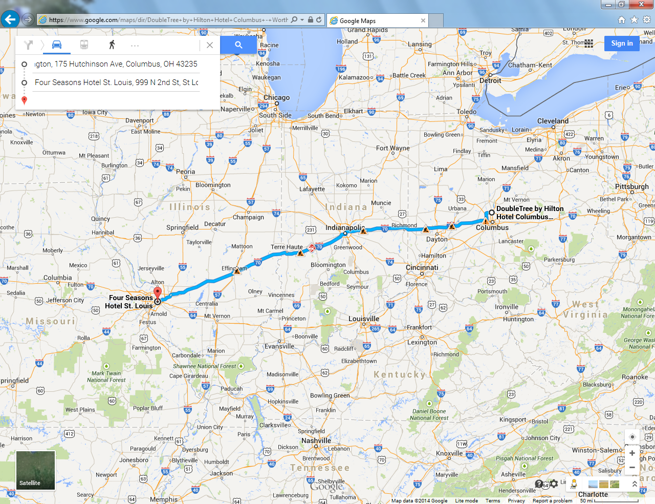
Dodging Rain Storms in South Dakota… Sioux City IA to Chamberlain SD

The route we have chosen this morning generally heads in a westerly direction, but gradually drifts north over the course of the morning.  We are taking route SD-50, a country road, passing through Yankton SD and then through a series of small villages and towns before eventually joining the interstate highway, I-90, just east of Chamberlain SD.  This leg of the journey is about 217 miles and it should take us, with stops, a little more than four hours.

As we begin, the weather is still very much a threat.

We depart north on I-29 for about the first seven or eight miles, before taking the exit for SD-50 in Vermillion SD, home to the University of South Dakota.[6]  SD-50 generally follows the route of the Missouri River, and is part of the Lewis and Clark Trail… but the river is generally out of sight about one to two miles south of the road.  The geography is considered to be “river bluffs”, but they are nowhere near as severe as the high limestone bluffs that we saw in Missouri.  The road rises and falls gently on gentle hills passing through farmland, approaching Yankton from the east.

To the left (south) the sky is brightening and the threat of rain seems less.  To the right (north) the sky is threatening and overcast and the threat of rain seems very real indeed.

We stop for gas in Yankton SD.  Yankton is the biggest town we will pass through this morning, with a population of 14,454.  Lewis and Clark were here in August of 1804, where they met with the Yankton Sioux.  It was the original capital of the Dakota Territories prior to statehood.[7]  The present city consists of two main roads meeting at an intersection in the center of town… Fourth St and Broadway.  The Missouri River is just a few hundred feet south of the center of town, Broadway St crosses the Missouri on the new Discovery Bridge, named for the Lewis and Clark Discovery Corp.

At the intersection of 4th and Broadway, SD-50 turns north, after an almost due westerly course from Vermillion.  The route respects the grid formed by the surveyed, one-square-mile sections that are the hallmark of the 19th century settlers’ attempts to impose order on the wild countryside they were trying to tame.   This will become the pattern for the next several hours:  travel north for a few miles, then turn left and travel west for a dozen or more miles, then turn right and travel north again for a short stretch, then west again.  Over and over.  In the beginning, we are more westerly than northerly, by the time we reach Champion SD, SD-50 will be a more northerly route than westerly.

As we are leaving Yankton, we encounter intermittent raindrops and can clearly see rain showers ahead of us. We have a short conversation about whether we should put on our spiffy rain suits.[8]   Before we can come to a decision, we take a left turn west and the threat of rain subsides.

Route SD-50 is our first successful run on a country road.  Our previous attempts in Missouri were disappointing, the rods were too twisty and turny, but this road is excellent.  Each segment is generally straight, with gentle up and down hills.  The topography is generally flat, so we can see easily for five or ten miles.  When we crest a small hill, we can see for twenty miles.  It is all farmland here, mostly corn, but some cattle ranches.

The weather is improving the farther we head west.  The brightening skies from the south have continued to improve and we can see blue sky to the south and sometimes the sun is actually peeking through.  To the northwest, we can continue to see dark skies and isolated showers.  We can see several rainstorms ten to twenty miles away to the north.  This is wide open country, at least to my New England eyes; in New England, you would have to be on top of a significant hill or mountain to be able to see as far.

Our strategy of heading west to get underneath the storm seems to be working.  The sun is out more often than not… and what had started as a solid overcast sky has turned into a series of puffy cumulous clouds.   Every ten miles or so, we pass through a small town.  Tabor.  Tyndall.  Avon.  Each with a population ranging from a few hundred to a thousand or so.  Wagner.  Lake Andes, with its large reservoir and lodges for sport fishing.  Geddes.  Most of these towns seem to consist of a gas station/convenience store a few houses, and a municipal building or two.  The countryside is pretty, this is a great motorcycle road.

We stop in Platte to stretch our legs and have a coffee.  The sky has cleared and is mostly sunny[9], although there are still isolated rain storms to the north.  Platte has population of 1230, a little bit bigger than most of the towns we have seen this morning.  They have a public library.  We stop at Casey’s General Store (and gas station).

As we are getting off the bike and taking off our helmets, a young man drives up on a Vesper and admires tour motorcycle, “Nice, bike!” he says, “You can’t go wrong with black!”  We thank him for the compliment.  The folks inside the store seem friendlier than we have met so far in Missouri or Iowa.  This will turn out to be the case for the entire time we are in South Dakota.

A few miles west of Platte, we get within a half a mile of the Missouri River and we turn north again.  We have to pause on a northbound leg of SD-50 to let a small rainstorm pass by.  It is about a half a mile in front of us and about a mile wide.  It is sunny all around us, with just this isolated shower, which passes in about ten minutes.  A few miles farther up the road we come to I-90.  We are 2000 miles west of our starting point on the Massachusetts section of I-90, six days ago.  Six days on a motorcycle and 2000 miles is starting to be a pretty respectable journey.  Literature and experience teach us that all journeys have the potential to be transformational, travelers have always experienced insights and epiphanies on long journeys.[10]

Our First Glimpse of  The Sublime…

In every landscape the point of astonishment is the meeting of the sky and the earth.
Ralph Waldo Emerson, On Nature

 After a few miles on I-90, we come up over a rise and a sign warns us of a steep downgrade for the next couple of miles.  We crest the hill and are greeted with a view of the Missouri River, a mile away and maybe 300 feet below us in elevation.   The river bluffs on both sides are covered with green grass, they are completely treeless.  The contrast of the vibrant green with the blue skies and white clouds is striking and will remain with me a long time.[11]  The river is almost a mile wide here[12], tinted to an almost aquamarine color by minerals dissolved in the water a thousand miles upstream.  We descend the hill and cross the river.  We climb the hill and when we crest it, it is clear that we have left the east for good and have really entered a western landscape.  It is achingly beautiful.  The treeless hills, undulating in all directions… endless, eternal, under a beautiful sunny sky.

There is a word to describe the source of the kind of emotions we experience, the feelings we experience, in response to beautiful scenery:  the sublime.   Ralph Waldo Emerson, essentially the founder of the transcendentalist movement, understood it well.[13]  Emerson tells us that the delight that we feel in the presence of the sublime is a result of a harmony between man and nature.  There is sanctity in the landscape and it can be a source of grace for us.

On his trip, Robert Pirsig[14] crossed the Missouri 180 miles north of here in Mobridge.  His description of his crossing is completely applicable to us:

“[We] cruise down [the] heavily trafficked [road] and then there it is at the bottom of the hill, the Missouri.  All that moving water is strange, banked by grass that hardly gets any water at all….  We coast down the hill, clunk onto the bridge and across we go, watching the river through the girders moving by rhythmically, and then we are on the other side.

We climb a long, long hill into another kind of country.

The fences are really all gone now.  No brush, no trees.  The sweep of the hills is so great John’s motorcycle looks like an ant up ahead moving through the green slopes.  Above the slopes the outcroppings of rocks stand out at the tops of the bluffs.”

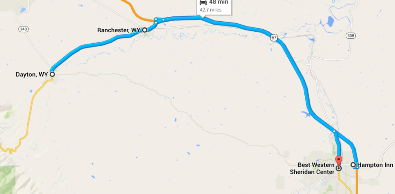
The good feelings we have from this morning continue and carry-over onto this next leg of the journey, 209 miles in distance to Rapid City SD, about another four hours for us in time, including stops.

More Rain, and the Sunshine… On the road to Rapid City SD

About fifty miles west of Chamberlain, we stop at a rest area near the town of Presho.  In keeping with the general friendliness of South Dakota, they have terrific rest areas… the best we have seen since New York State.  The skies are threatening a little more, with showers off to the north side of I-90.  We have picked up a pretty strong cross wind, which makes riding the motorcycle a little more challenging.  We pick up a couple of maps of South Dakota, and Rapid City in particular.  The rest area staff is amazingly hospitable and helpful.

A gentleman sees our helmets and stops to ask us about our trip.  He’s impressed that we have come all the way from Massachusetts, he is a motorcyclist himself… and like most motorcyclists has dreamed of making a big cross country trip.  “How are you liking those crosswinds?” he asks and I concede that they are challenging.  The winds are about fifteen to twenty miles per hour with 25 mph gusts.  When we catch a gust the bike leans into the wind, seemingly on its own… although in reality it is my own body responding to the changing environment.  It is a collaborative effort between wind, machine, and rider.  He tells us about a great motorcycle road near Rapid City:  route US-16 south from Rapid City and into Wyoming.  We promise to look into it as we say our goodbyes.

A few miles past Presho, we start to pick up some raindrops, significant enough for us to stop and put on our spiffy rain suits.  The road is wet and the rains suits protect us from the mist thrown up by the tractor trailer trucks.  We pick up a few raindrops here and there, but mostly we can watch the storms off to the north.  The sun comes out in between the stretches of clouds.  The land remains starkly beautiful, inspiring.

I am sensitive to the wind… it has become an integral part of the ride… and it has been shifting.  This makes sense as we are far enough west now that we are due south of the large low pressure weather system in the north.  Its counterclockwise rotation is now starting to produce winds from the west as opposed to the southerly winds we were experiencing this morning.  This is tending to send the storm cells toward us as opposed to blowing them across are path.

The landscape is just as beautiful with the backdrop of storm clouds and lightning as it was with blue sky and cumulus clouds.

The bike needs gas, so we stop in Kadoka.  There are thunderstorms all around us and rain is starting to fall.  Across the street, a half dozen bikes are taking shelter under an abandoned gas station canopy.  We decide take shelter have a snack at the Subway restaurant next door where we split a meatball sandwich and a salad.  We meet some folks there, who also want to know about our trip, it turns out that they also ride… it seems that there are a lot of motorcyclists in South Dakota.

Finally the rainstorms go by and we can travel the last 100 miles to Rapid City without further incident.  The storm clouds are still to the south and the north, but the sun is breaking through sending vast shaft of light across the countryside, creating more beauty.

Emerson has talked about this too, the collaboration of landscape, light, and observer:

“The ancient Greeks called the world κοσμος, beauty.  Such is the constitution of all things, or such the plastic power of the human eye, that the primary forms, as the sky, the mountain, the tree, the animal, give us a delight in and for themselves[15]…  The eye is the best of artists… [and] as the eye is the best composer, so light is the first of painters.  There is no object so foul that intense light will not make beautiful.  And the stimulus it affords to the sense, and a sort of infinitude which it hath, like space and time, make all matter gay.”

It has been a great day, the best so far.

Theology or Geology?  …a visit to an alternate world…

Ruth has picked out a terrific hotel for us in Rapid City, the Hotel Alex Johnson.  It is one of the oldest hotels in town, but has been updated into a kind of boutique hotel.  Rapid City seems like a nice town, with a western-hippie-counterculture kind of feel.  There is live music on the plaza and a lot of families out and about.  The weather is sunny, the clouds are moving along.  Everyone seems to be smiling.

We find a terrific steakhouse and get a table.  The friendly server[16] wants to know where we are from, and we tell her about that and about the motorcycle trip.  Her name is Dawn.  We ask her where she is from and she tells us from Fayetteville AR.  I ask her how it comes about that she is in Rapid City.  She volunteers that she was a theology major at the University of Arkansas, and that therefore the Black Hills are the place to be.  She has previously worked for the US Forest Service.

She takes our order and we enjoy our wine.  I mention to Ruth that Dawn seems like a fine young person, full of energy and with her life ahead of her.  I wonder out loud about whether in addition to her theology degree, if she was ordained as a minister in any church.  Ruth is confused.  She tells me point blank:  “She said she was a Geology major, not a Theology major.”  I am chagrinned.

After we have eaten, and declined dessert, Dawn brings us the check.  She asks us where we are heading next and we allow as, since we are here, we thought we would go take a look at Mount Rushmore in the morning before heading west to Wyoming.  She lights up and tells us not the miss the Needles Highway, a scenic road that winds through the Black Hills Nation forest.  She tells us that the rock formations are beautiful.

I decide to resolve this geology/theology uncertainty, so I ask a simple question:  “So as a geologist, you recommend them?”  She lights up with enthusiasm:  “Yes!  The rocks are pre-Cambrian granite, more than two billion years old.”  We thank her, pay our check, and depart.

Later, over a nightcap back at the hotel bar, I think about this conversation.  I’m a physicist, so sometimes I wonder how things can go differently.  Quantum mechanics teaches us that the answers that we get depend on the questions we ask.  There is an uncertainty principle at work.  If we ask about a particle’s position, we can find that out… but we can’t find out about its momentum.  If we measure its momentum, we lose the ability to measure its position.

I’m hung up on this geology/theology uncertainty.

Theology or Geology?  …a visit to an alternate world…

Ruth has picked out a terrific hotel for us in Rapid City, the Hotel Alex Johnson.  It is one of the oldest hotels in town, but has been updated into a kind of boutique hotel.  Rapid City seems like a nice town, with a western-hippie-counterculture kind of feel.  There is live music on the plaza and a lot of families out and about.  The weather is sunny, the clouds are moving along.  Everyone seems to be smiling.

We find a terrific steakhouse and get a table.  The friendly server[17] wants to know where we are from, and we tell her about that and about the motorcycle trip.  Her name is Dawn.  We ask her where she is from and she tells us from Fayetteville AR.  I ask her how it comes about that she is in Rapid City.  She volunteers that she was a theology major at the University of Arkansas, and that therefore the Black Hills are the place to be.  She has previously worked for the US Forest Service.

She takes our order and we enjoy our wine.  I mention to Ruth that Dawn seems like a fine young person, full of energy and with her life ahead of her.  I wonder out loud about whether in addition to her theology degree, if she was ordained as a minister in any church.  Ruth is confused.  She tells me point blank:  “She said she was a Geology major, not a Theology major.”  I am chagrinned.

After we have eaten, and declined dessert, Dawn brings us the check.  She asks us where we are heading next and we allow as, since we are here, we thought we would go take a look at Mount Rushmore in the morning before heading west to Wyoming.  She lights up and tells us not the miss the Needles Highway, a scenic road that winds through the Black Hills Nation forest.  She tells us that the rock formations are beautiful.

I decide to resolve this geology/theology uncertainty, so I ask a simple question:  “So as a theologist, you recommend them?”  She lights up with enthusiasm:  “Yes!  The rocks are pre-Cambrian granite, the foundations of the world.  We can see the proof of God’s creation right before our eyes.  They are the sublime.” We thank her, pay our check, and depart.

Later, over a nightcap back at the hotel bar, I think about this conversation.  I’m a physicist, so sometimes I wonder how things can go differently.  Quantum mechanics teaches us that the answers that we get depend on the questions we ask.  There is an uncertainty principle at work.  If we ask about a particle’s position, we can find that out… but we can’t find out about its momentum.  If we measure its momentum, we lose the ability to measure its position.

I’m hung up on this theology/geology uncertainty.


Dodging Thundersons in our fashionalble rain suits in Kadoka SD

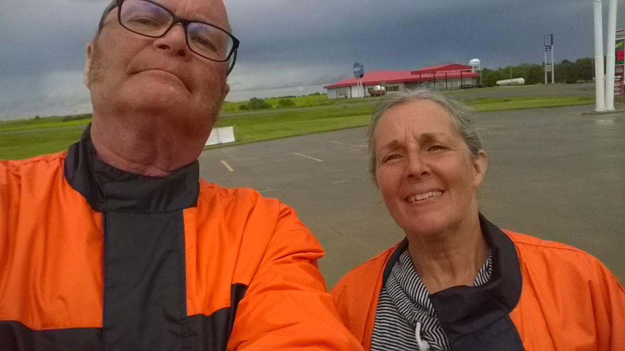
Dodging thunderstorms in our fashionable rain suits in Kadoka SD

Summary

Date:  June 28, 2014
Departure Location:  300 3rd St. Sioux City IA
Arrival Location:  523 6th St. Rapid City, SD
Total Miles:  433
Total travel time: 10:07
Total miles/total travel time: 43 mph
Number of States:  2 (Iowa, South Dakota)
Number of Watersheds:  1 (Mississippi River… Missouri River Division)
Stops:  2 (Yankton SD (gas), Platte SD (leg stretch, coffee), Presho SD (leg stretch). Kadoka SD (gas, rain delay, snack))
Weather:  Partly Cloudy AM, Thunderstorms PM
Temperature:  7:00 AM (Sioux City) 75 ͦ  F, 12:00 Noon (Platte SD) 78 ͦ  F, 7:00 PM (Rapid City SD) 73 ͦ  F
Lodging:  Alex Johnson Hotel, Rapid City SD
Restaurants:  Subway, Kadoka SD; Delmonico Grill, Rapid City SD

[1] We are using Ruth’s primitive cell phone as the alarm clock, since my travel alarm clock was a victim off my less than robust luggage packing process.

[2] This is the farthest north that the Lewis and Clark Expedition reached.  Lewis had been hoping the Missouri River would continue farther north into what is now Manitoba.  Every mile they went further north had the effect of taking land away from the British

[3] Total miles divided by total travel time.

[4] Or, more likely, creating some slack in the schedule in case we encounter additional weather delays.

[5] The “free” breakfast buffet seems to be a standard feature of IHLCs.  Sometimes they have a hot buffet, sometimes only cold.  They are all unmemorable, but will become a part of our lives for the next week.

[6] Go Coyotes!

[7] The capital was moved to Bismarck in 1883.

[8] It is a typical motorcycle conversation:

“Do you think we should put our rain suits on?”

“WHAT?”

“DO YOU THINK WE SHOULD PUT OUR RAIN SUITS ON?!!”

“I CAN’T HEAR YOU!!!”

[9] I’ve always been pathologically fascinated with the etymology of weather terms.  Is mostly sunny the same as “partly cloudy”?  What is the spectrum of weather?  Here is a possible example:  Cloudy; Partly Cloudy; Partly Sunny; Sunny.  Where does “mostly sunny” fit in?  What goes in between “Partly Cloudy” and “Partly Sunny”.  These are the kinds of stupid things you can think about when you have plenty of time driving around on a motorcycle (see Day 3 for other examples).  In today’s case, though, there is at least a semblance of some kind of philosophy of language if not outright metaphysics.

[10] The oldest form of fiction is the picaresque novel, which is just folks traveling around having adventures and learning from their journeys… although we readers generally learn more than the protagonists… and we readers tend to learn something about ourselves as well.  Canterbury Tales, Don Quixote, Moll Flanders…the great American classic, Huckleberry Finn… and of course, for us Lowellians… On the Road.  I think often of the late Charlie Jarvis, my teacher at the University of Lowell, who helped me to connect the dots between these books.  He was a personal friend and biographer of Kerouac and an extraordinary thinker.  I am richer for the time I got to spend with him.

[11] I think of the dictionary definition of vista which means not just a beautiful view of land or water, but a vision of the future of possibilities; suddenly the two meanings tie together, seamlessly.

[12] The river here is deadwater behind the Fort Randall Dam at Wagner SD, thirty miles downstream.  The river here is a long narrow lake, Lake Francis Case.

[13] Emerson wrote, in On Nature, of the great beauty of New England forests and landscapes, where he felt he could experience the presence of God more directly than he could in any church, “Here is sanctity that shames our religions.”

[14] Robert M. Pirsig, Zen and the Art of Motorcycle Maintenance.  William Morrow and Company © 1974

[15] Emphasis added.

[16] She is friendly like everyone else we have met in South Dakota.

[17] She is friendly like everyone else we have met in South Dakota.


4 Comments

Filed under Journeys in Space

Journeys in Space: An Excellent Motorcycle Adventure! Day 5!

An Excellent Motorcycle Adventure!  Day 5!

Kansas City to Sioux City with Rain Delays

Kansas City to Sioux City with Rain Delays

Kansas City to Sioux City

We have an easy day planned today, just 300 miles or so up to Sioux City.  The first couple of hundred miles will bring us to Omaha, one of my favorite cities in the Midwest, and there are some Lewis and Clark sites to visit at Council Bluffs.  I’m hoping to have a nice lunch in Omaha, as my research has not shown much fine dining in Sioux City for this evening.

We’re planning to use the interstate, I-29, for the first two thirds of the trip to Omaha, then take NE-75 North.  NE-75 parallels the Missouri River for a good bit, so we are interested to see what the geography looks like in that part of the watershed.  It looks less hilly, twisty and turny than the county roads we traveled in Missouri… so there shouldn’t be much challenge today at all.  A nice relaxing day.

We depart Kansas City a little before 9:00 AM.  The skies are overcast, but it is not too cold.  You don’t have to get very far out of town before you are right back in rural America… more corn fields.[1]  The land in this part of the country is surveyed into square mile sections, each with 640 acres.  Dirt (or sometimes paved) roads separate the sections.  Thirty-six sections make a township, at is common for all the roads in a township to be built on the same kind of a north-south-east-west grid.  The interstate highway, or course, does not respect the grid at all.  It goes where ever the federal highway designers thought that it should.  I guess this an example of what we now call “Federal Government Overreach”. Roads are cut through by I-29 and they just dead end at the highway, and we can see them pick up again on the other side of the highway right of way… sometimes the power lines cross the highway to pick up the section road on the other side.[2]

We cruise along I-29 with the skies becoming darker and more ominous with each passing mile.  We hadn’t been very diligent about checking our ASTT[3] because it was good weather in Kansas City and only about three hours to Omaha.  But at about halfway, things are starting to look very ominous indeed.  We watch carefully for drivers with their window wipers on the southbound side of the highway.  Sure enough, we see a few window wipers and we feel our first big drops of rain.

The road sign at the side of the highway indicates an exit in two miles, for Craig MO.  Big drops are still coming down, but no deluge yet, we make the exit and turn left… following signs for a Sinclair Station.[4]  We pull into the Sinclair station (there is no garage, but there is a convenience store) and are under the canopy at the gas pumps when the deluge begins.

We decide to fill up with gas, although we really don’t need any, just so that it seems like we aren’t completely poaching.  There is another motorcycle here, they are putting on their rain suits and we decide to do the same.  They don’t seem in the mood to chat, and they soon pull out.  Ruth goes into the convenience store and comes out with bottled water and some maps.[5]

She remarks that the people inside didn’t seem too friendly.

Just then, a big BOOM, CRASH of thunder and lightning and we know that we aren’t going anywhere for awhile.  We stand around under the canopy and try to “enjoy” all of this as best we can.  We are getting sporadic updates on the ASTT… dependent on signal strength.  The storm is moving NE, which means if we want to avoid it we need to head west… and try to get around underneath it.

Ruth studies the maps and comes up with a genius idea, at least I think it is genius.  She is more modest about it.  She has determined that the side road we are on, MO-59, continues north and in about seven miles connects with a route that will take us west, hopefully around the storm.  All we have to do now is wait for the rain to stop… which is does presently… in about 45 minutes.[6]

Finally a break in the rain.  We wait about another ten minutes until we are sure that there is no more thunder and lightning, and then we are off.

It turns out that Ruth’s modesty about her route was well placed.  In order of occurrence:

  1. It starts to pour again in about two miles.
  2. It starts to thunder and lightning again
  3. This country road is narrow, poorly paved, with no shoulders and a 65 mph speed limit
  4. This country road, which we hoped would be idyllic, if somewhat wet, is the main truck route to Fairfield MO.  I am driving somewhat slowly due to poor visibility from the rain
  5. The combination of 4 & 5 means I quickly pick up a caravan of irate tractor-trailer truckers behind me.

I pull off onto a dirt road and we decide to wait for the rain to end again…

Fortunately our spiffy rain suits keep us dry and after awhile the rain stops again.  Unfortunately, this dirt road is not the best surface on which to muscle the bike around as I try to maneuver it back onto MO-59.  The bike, fully loaded with me, Ruth, and luggage weighs about 1350 lbs.  I have Ruth get off and she has to help push as we manually perform a three-point turn.  Meanwhile, the big tractor-trailers are passing by at 70 mph… amused, I hope.

We decide that the interstate highway will be safer… the two lanes means that I can drive slowly and the trucks and other traffic can pass… and the extra traffic will help dry the road out sooner, improving traction.

So, with our collective tails between our legs again[7] we get back on the interstate.

We have to stop again in Rockport MO, just before the Iowa border.  We manage to do this at a fully equipped truck stop, which means we can get snacks and a drink and that our ASTT devices have good connections.  We receive weather warnings:  “WARNING LOCAL FLOODING IN BROWNSVILLE”, about 5 miles away… “WARNING HEAVY RAINS WEST OF OMAHA”, about 70 miles away… “WARNING HEAVY RAINS AND LOCAL FLOODING…”, well… you get the idea.

After awhile the rain stops and we can resume our trip north,  We give up on Council Bluffs, we give up on lunch in Omaha, we give up on the idyllic route NE-75.  We just go up I-29.  We do manage to pass by the burial place of Sargeant Charles Floyd, the only person to die on the Lewis and Clark Expedition.  We arrive in Sioux City where Ruth has selected from the available assortment of IHLCs[8]

The restaurant choices, as I feared, are indeed unmemorable.

Sergeant Charles Floyd Memorial, Sioux City Iowa (c) 2014 Tim Carey

Sergeant Charles Floyd Memorial, Sioux City Iowa (c) 2014 Tim Carey

Summary

Date:  June 26, 2014
Departure Location:  1111 Grand St., Kansas City MO
Arrival Location:  300 3rd St. Sioux City IA
Total Miles:  297
Total travel time: 9:57
Total miles/total travel time: 30 mph
Number of States:  2 (Missouri, Iowa)
Number of Watersheds:  1 (Mississippi River… Missouri River Division)
Stops:  2 (Craig MO (gas, rain delay), Rockport (rain delay))
Weather:  Partly Cloudy AM, Thunderstorms PM
Temperature:  7:00 AM (Kansas City) 75 ͦ  F, 12:00 Noon (Craig MO) 71 ͦ  F, 7:00 PM (Sioux City IA) 73 ͦ  F
Lodging:  Stone Creek Inn, Sioux City IA
Restaurants:  Luciano’s, Sioux City IA

——————————————————————————-

[1] As I have mentioned before, these cornfields, tens of thousands of square miles have been driving me crazy.  How did they possible develop all of this in the 19th century?  I have since done some research.  The first mechanical planters (horse drawn) were invented and developed in 1701 by Jethro Tull.  The first mechanical reapers and thresher was developed by Cyrus McCormick in 1831,  The first mechanical reaper/thresher was also invented by McCormck in 1847.  So I guess the answer is that agriculture in the Midwest was enabled by mechanization right along.

[2] When I was a boy, I lived on a short dead end street that had been cut-off in just this way by the construction of the F.E. Everett turnpike in Nashua NH.  I could stand at the fence at the edge of the highway right of way and see the continuation of my road on the other side.  I wondered where the road went and if there were people over there… I was maybe six or seven years old.  When I got older, maybe ten or twelve, I would take my bicycle across the highway and try to find the continuation of my street, without much success.

[3] Advanced Storm Tracking Technology… this is a cellphone with the weather.com app (see previous posts for a complete description).

[4] Howis the Sinclair Gasoline Dinosaur Logo still relevant?  They need some market research and focus groups to come up with a new logo, yes?

[5] This is a good time for a confession, a confession that I have already made to Ruth.  I ordered a set of 26 Rand McNally road maps, for every conceivable route that we could take before we left Cambridge.  Where are they?  On my desk.  Somehow my packing process wasn’t very robust, I guess.

[6] This is going to trash our daily “total mpg” metric.

[7] See Day 4 for another instance of the roads being better that me

[8] Interstate Highway Lodging Choices:  Days Inn, Comfort Inn, Hampton Inn, etc., etc.,


2 Comments

Filed under Journeys in Space

Journeys in Space: An Excellent Motorcycle Adventure! Day 4!

An Excellent Motorcycle Adventure!  Day 4!

St Louis to Kansas City

St Louis to Kansas City

An Excellent Motorcycle Adventure!  Day 4!

Sunrise from our room at the Four Seasons, St. Louis (c) 2014 Ruth Carey

Sunrise from our room at the Four Seasons, St. Louis (c) 2014 Ruth Carey

Ruth has really done an excellent job with this hotel.  The room is spectacular, the view of the Mississippi River at dawn is spectacular.  We kind of get the impression, though, that it is not really a Four Seasons… maybe they are just licensing the name or the brand.  The restaurant last night was not fantastic.  The employees don’t seem to know what they are doing.

On the other hand… it is a brand new hotel, so maybe they are still shaking things out.  Maybe everybody is still getting trained.  It is associated with the new waterfront casino, so maybe that has everyone confused.  Or maybe the casino patrons are not so demanding of service at these high prices, they just want to GET TO THE CASINO…

I just don’t know.

But the room, the view, is spectacular.

Today is our first real day of vacation.  We have been speeding along the interstate highways, racking up miles instead of racking up experiences… to day our goal is to take it slow, see some sights… see the country side.

NO INTERSTATE HIGHWAYS TODAY!!!!!!!!!!!!!

Thomas Jefferson National Expansion Monument

Within a short walk from the hotel is the Thomas Jefferson National Expansion Monument.  This is commonly known as the St Louis Arch, Gateway to the West.  The arch is set in a park of about 90 acres with a view of the river and of the Old Federal Courthouse[1].  There is a lot of construction going on right now… you can’t get down to the riverboats on the water…

The arch is spectacular.  It is EXTREMEMLY slender, being only about 50 feet wide, rising 600 feet into the air.  A truly spectacular piece of art, architecture and engineering[2].

St Louis Arch.  The Gateway to the West (c) 2014 Tim Carey

St Louis Arch. The Gateway to the West (c) 2014 Tim Carey

Bellefontaine Cemetery

Ruth is not a fan of cemeteries, so it takes a lot of convincing and wheedling, and promises of cocktails later, to get her to agree to spend an hour driving to, and visiting, the Bellefontaine Cemetery, the final resting place of Captain William Clark who died in 1838.  Captain Clark is the progenitor of eight generations of St Louisians[3].

William Clark Grave in Bellefountaine Cemetery, St Louis MO.  (c) 2104 Tim Carey

William Clark Grave in Bellefontaine Cemetery, St Louis MO. (c) 2104 Tim Carey

While we were wandering around the cemetery, we discovered a “bonus grave”[4].

A bonus grave (c) 2014 Tim Carey

A bonus grave (c) 2014 Tim Carey

St Charles, MO

Lewis and Clark and the Discovery Corps departed on their epic adventure from St Charles, MO on May 21, 1804.  It seemed an appropriate place to visit.

St Charles was founded as a French settlement in 1769.  St Louis and St Charles were transferred back and forth between French and Spanish rule several times, depending on how various wars in Europe were being played out.

There is a small museum, The Lewis and Clark Boathouse and Nature Museum, that is well worth a visit.  It is staffed by fanatical and rabid Lewis and Clark aficionados, including people that spend their spare time re-enacting portions of the journey.  The museum includes artifacts from the expedition and replicas of the boats used during the journey.


Lewis and Clark brought this silver plated medals to give to the indian tribes they met on the way.  By all accounts the Indians were not impressed with these gifts.  The would have preferred blue beads, firearms, and whiskey.  (c) 2014 Tim Carey

Lewis and Clark brought this silver plated medals to give to the indian tribes they met on the way. By all accounts the Indians were not impressed with these gifts. The would have preferred blue beads, firearms, and whiskey. (c) 2014 Tim Carey

I was surprised by how large the boats were.  The keelboat was 60 feet long.  Even the smaller boat, the pirogue, was 48 feet long.

After visiting the museum we walked around St Charles Village, looking for something (just a bottle of water) to drink.  This was more of a challenge that we anticipated.  I had actually suggested to Ruth that we buy a couple of bottles of water in the museum gift shop, where they were for sale at a very reasonable price.   She thought that maybe we could do better somewhere else, and it is always good to walk, so we spent the next hour wandering around St Charles looking for a convenience store, or something, where we could get a couple of bottles of water.  It was a hot day and we were thirsty.

St Charles Villaage is an incredible picturesque, attractive, and charming community.  Main Street dates to the founding of the village in 1769 (although most of the building date only to the mid to late 19th century).  There are charming restaurants.  There are charming clothing boutiques.  There are charming antique stores.  There are charming art galleries featuring the works of St Charles artists.  There are charming knick-knack stores.  There are charming places where you can rent a bicycle for the nearby Katy bike trail[5].  There are even charming real estate offices were you can meet with people that will sell you your very own piece of this picturesque, attractive and charming community.

However, there isn’t a convenience store to be found.

We finally got a couple of bottles of water at the charming ice cream and fudge shop.  Very picturesque.

It’s time for some real motorcycle riding!

So far on this trip, we having been cranking out the miles in the interstate highway system, to get to St Louis, to satisfy some time constraints, and while everything has been great, great, great… interstate highway travel is not how we generally like to spend our motorcycling time.

The preferred route on a motorcycle is usually an idyllic, country road.  One that wends and winds its way through the country side.  Preferably a two laner through farm country, with glimpses of lakes or rivers and streams.  Where people wave as you pass by.

I’ve identified what I think is the perfect route for our next leg of the trip to Kansas City MO. [6] Route MO-94 is a wending, winding road passing through the country side.  It passes through idyllic farm country, with occasional glimpses of the Missouri River or tributary rivers.  It look perfect.  It runs for about 100 miles, and then we can switch to an even prettier road, Route MO-100, which will take us through some charming towns and villages.  Then we rejoin MO-94 for the final run into Kansas City.  The sun is shining, it is a beautiful day.

The trip starts out in a wonderful fashion, soon after leaving St Charles we cross the Missouri River on a wonderful steel box trestle bridge.  It must date from the 1930s, estimating from the riveted steel box structural elements.  There are bridges like this all over American, gifts to us from our great-grandparent who built them for us during the great depression.

Then we start motorcycling in earnest.  The topology of the land is hilly.  These are limestone bluffs overlooking the river.  We go up and down and back and forth and up a STEEP hill and around a HAIRPIN turn and then OHMYGOD a steep drop and turn and then a short straightaway and then another hill and another hairpin turn and then do it all again.  And again.  And again.  For the next two and a half hours.

In some ways driving a motorcycle is easier than driving a car.  They can be more maneuverable.  The respond to the road.  You bank into the turns.  Some roads are more difficult than others.  The Kangamangus Highway in NH is a great motorcycle road.  It is wide, well constructed.  The banked turns are well analyzed.  It is an almost effortless ride.  The Pacific Coast highway is a more challenging road, especially as you get North toward Big Sur.  There are many hairpin turns and switchbacks.  The road is narrower.  But it is navigable and lovely.

MO-94 was designed by Satan.

The nominal speed limit is 55, but that is a joke.  Every hill, every turn has a custom speed limit, you know, one of those signs that say “40 MPH” and accompanied by a little squiggly symbol that means twisty-turny.  Or “20 MPH” accompanied by an curved arrow indicating a sharp turn.  I would say that the average speed limit is closer to 45 mph than to 55 mph.  We averaged 38 mph.  It was tough.

I think the thing that amazed me the most was the amazing changes of directions that happened at the top of blind hills.  You would be on a steep banked uphill turn to the left, say.  You are locked into a trajectory where the speed and angle of the bike will take a safe path over the roadway that you can see.  It is a blind hill, so you can’t see what is on the other side.  Typically, you will start the turn closer to the yellow line in the middle of the road and swing slightly toward the right edge coming back closer to the yellow line at the crest.  Often, there is a steep drop off on the right side.  As you crest the top of the hill, though, SURPRIZE!, the road goes sharply right, although it is still banked for a left turn.  Yikes!  You have to change angle and speed to adjust.  You should really downshift, but you don’t have time, you are fighting the turn every inch of the way.  And then OHMYGOD another 20MPH sharp left turn!

Well, we completed MO-94, but I can’t say I was proud of my driving.  I was always out of sync with the road, up shifting too late, down shifting too early, not having the right speed on the turns.  Humbling.[7]

Route MO-100 was slightly easier, it had only been designed by one of Satan’s demons… in an apprenticeship program I guess.  When we got through that stretch, again only averaging only 40 mph and it was time to rejoin 94, I tucked our collective tails between our legs and bailed out.  We jumped onto MO-50, a wonderful two laner, and sometimes four laner, with no traffic that passes through lovely towns and the capital of Missouri, Jefferson City.

We finally arrived at Kansas City, our destination for the night.  Ruth did an amazing job with the hotel, an in-budget-boutique-hotel in the up and coming Kansas City Power and Light District.[8]  We had a fabulous dinner and declared victory on the day.

——————————————————————————————–

Summary

Date:  June 26, 2014
Departure Location:  999 N 2nd St., St Louis MO
Arrival Location:  1111 Grand St., Kansas City MO

Total Miles:  327
Total travel time: 10:03
Total miles/total travel time: 33 mph[9]

Number of States:  1 (Missouri).
Number of Watersheds:  1 (Mississippi River… Missouri River Division)
Stops:  4 (Bellefontaine Cemetery, St Charles MO (museum), Linn MO (leg stretch), California MO (gas))
Weather:  Partly Cloudy AM, Partly Cloudy PM

Temperature:  7:00 AM (St Louis MO) 78 ͦ F, 12:00 Noon (St Charles MO) 85 ͦ  F, 7:00 PM (Kansas MO) 83 ͦ  F
Lodging:  The Ambassador Hotel, Kansas City MO

Restaurants:  801 Chop House, Kansas City, MO


[1] This courthouse is where the famous Dred Scott case started.

[2] Like all classical arches, it takes the shape of a catenary.  A catenary is a mathematical function, based on hyperbolic trigonometric functions, that balances an evenly distributed stress against gravity.

[3] Ironically Meriwether Lewis died childless, murdered in Tennessee[3] in 1809.

[4] The cigarette pack seems to have been left as an offering by an acolyte or devotee.

[5] A terrific rails to trails conversion that runs for 240 miles through Missouri

[6] I use the singular first person pronoun here, “I”, as opposed to the plural “we”.  As you will see, blame will need to be assigned later.  “Success has many parents, but failure stands alone.”

[7] We did have another near brush with An Alternate World, we were cresting over one of these blind hills, turning to the left and at the top of the hill, the road continues left at the crest.  We are close to the yellow line as we crest.  As we top the hill I can see a Ford 350 pickup truck coming up the other side and about to cross into my lane.  The road is banked the wrong way, so any sudden moves will send me off to the right into the ravine.  We are pretty much locked into our trajectory at this point, so all we can do is watch.  He is about 150 feet away and the closing velocity between the two vehicles is about 100 miles an hour, so there is just about a second before we crash.  Fortunately he jerks his truck to his right, our left, and we avert disaster.

[8] This is an area of downtown Kansas City here a bunch of old buildings have been transformed into trendy hotels, restaurants, bars and nightclubs.  The centerpiece is an outdoor music stage featuring national and regional acts, mostly country western music (as you might expect).  Tonight’s bands were Travis Martin & Cassadee Pope.  There were about 2000 young women traveling in packs of six to eight, in standard uniforms of mini-dresses and cowboy boots (or alternately, daisy dukes and cowboy boots).  There were about 5000 young men traveling in smaller packs of two or three, in standard uniforms of cargo shorts, tee shirts and flip flops.  We had left the scene before things reached what seemed to be the individually predestined conclusions.

[9] Ruth has protested this calculation.  She wants to take out the time and miles we spent at the cemetery and at St Charles.   By her reckoning we did 294 miles in 6:47, 43 miles per hour.

3 Comments

Filed under Journeys in Space

Journeys in Space: An Excellent Motorcyle Adventure! Day 3!

An Excellent Motorcycle Adventure!  Day 3!

Columbus to St Louis

Columbus to St Louis

Columbus OH to Richmond IN 

Today will be another long day of Interstate Highway driving.  We are trying to make it to St Louis, MO by tonight, after that… we will proceed at a more leisurely pace.

There is a chance we will be dodging thunder storms again today, so we watch the television and utilize our ASTT devices[1], everything looks clear so off we go… an early start at 7:13 AM.  We are a little confused as to how to find I-70 West.  Downtown Columbus has undergone some urban renewal and someone thought it would be cute to pave all the east west streets with cobblestones.[2]  This would be deadly on the motorcycle.  So we keep driving around until we kind of discover a place where the Garmin GPS unit could direct us without using cobblestone streets.[3]  Finally we are on our way.

Immediately, the skies are threatening and it is starting to rain.  What’s up with that?  The weather report and the ASTT sowed clear skies.  We could have delayed our departure until it passed.  Disappointing, but part of the world I guess.  A lesson not to believe too much in technology.  A lesson that when the rain gods want to rain a little, you’re gonna get wet. There is an exit about two miles ahead so we make for that, hopefully there will be a gas station with an awning we can park under while we wait for the storm to pass.

Just as we get to the exit, blue sky starts to break through, so we continue without stopping.   My legs are pretty wet, and the windshield is covered with raindrops so it is hard to see.  We spend the next hour drying out.

“… Rolls along passes houses, farms, and fields…”

From the song City of New Orleans

by Steve Goodman

This part of Ohio, west of Columbus, is all farms.  In fact, it appears to be all corn.  It looks to have been done in three plantings.  In some of the fields the corn is about a two feet high; some fields are about a foot high; some have just been planted.  I shout back to Ruth, “Wow!  That’s a lot of corn!”  Silly, I know, must it really was a lot of corn.  I didn’t realize that it was only the beginning of the corn.

Obviously today, farming is highly mechanized.  In the USA we have the lowest percentage of our labor force engaged in agriculture of any country in the world… and we manage not only to (basically[4]) feed ourselves, but we export food too.  I’m looking at all of these fields, tens of thousands of acres, thousands of square miles and I’m thinking back to when this was all done without mechanization.  It makes no sense that it could have been, at least to me.

Anyhow, I start humming the old Steve Goodman song City of New Orleans.  I’m pretty hung up on the lyric about rolling along pass houses farms and fields.

When you are on a motorcycle, you have a lot of time to yourself… even if you have a passenger.  The motorcycle environment is just not conducive to scintillating conversation.[5]  You are essentially alone. So your mind wanders and you can think about all kind of things, not all of them world class thoughts or philosophy.  Some of them pretty stupid.  I had this idea that the motorcycle trip would enable me to clear out the cobwebs, reflect on life.  I’ve had some challenges in the last year and I thought reflection would do me some good.  Contemplation.  Think big thoughts.

But instead, I find myself thinking about vehicle names.

In our family we are a little wacky in that we are one of those families that names our vehicles.  It is a little embarrassing to admit it.  I’m not sure how it really started.  Our first car, a 1974 Ford Pinto wagon with Firestone 500 radials[6], was named “Bubby”… or “Bubs” for short.  Our second car, a 1982 Mazda 626, was “Mona”.  We had a long series of Volvo sedans:  “Earl”, “Cousin Earl”, “Grandpa Earl”, etc.  Ruth’s current car is “Lulu”.  My current shitbox is “Bessie”.

Silly I know.

Anyway Ruth has been after me to name the motorcycle.  Our previous motorcycle had a name, “Siggy”[7], but I have been resisting naming this one.  She has been pretty persistent about it, and I have been pretty consistent about it.  But, I have to admit that I just haven’t been able to come up with a good name.

Looking though, at all that corn, and all those houses, farms and fields… strikes me that I could name the motorcycle City of New Orleans.  It’s perfect.  That way I can sing “Riding on the city of New Orleans… rolls along pass houses farms and fields”.  It is perfect.  Of course I’ll have to rewrite a few lyrics to make it come out right.  I’m not sure what to do with the old men in the club car.  Or the mothers with their babes asleep, rocking to the gentle beat.

From there I start to think about names in general.  Why does the bike even need a name?  What about “The Bike with No Name”.

Richmond IN

We crossed into Indiana and immediately I stop thinking about names of motorcycles.  There are two things going on.  The first is that the road has become terrible, poorly maintained, bumpy, potholes, patches.  In a car these are an annoyance, on a motorcycle they can be deadly.  The second is that there are all of a suddenly all these wacky billboards.

I’m kind of surprised that the road is so bad.  I normally don’t drive the motorcycle much on interstate highways, preferring back roads and country roads.  We are only on the interstate because of time constraints.  A bump or a pothole on a back road can be dealt with, there is usually not much traffic and speeds are slower.  A bump or a pothole on the interstate at high speed is a major event.

The wacky billboards are interesting.  There are a whole series of them advertising “Warm Glow” which we determine is some kind of candle outlet store.  After a series of billboards, we figure out that they specialize in scented candles.  After a few more billboards, I’m starting to think a candle or two would be nice to have along for the trip.  You know… kind of romantic.  The last billboard is the best.  It turns out that Warm Glow is not just a candle outlet store.  It’s like a destination rest stop too.  A mini theme park of candles.  A big tag line on the billboard claims:  “THE CLEANEST RESTROOMS ON I-70”.  Wow.  It’s hard to pass that up.

Excitedly, I ask Ruth if she needs to go to the bathroom.[8]  But she doesn’t so we travel on.

A Brush with an Alternate World

In some ways a motorcycle is more maneuverable than an automobile.  It can swoop left and right.  I can fit through small spaces.  You can use the whole road when you are riding in a way that you just can’t when you are driving a car.  You swoop and glide.  It’s like skiing a little bit.

But you don’t make any sudden moves on a motorcycle.  You can’t jerk the bike one way or the other.  Especially not a big bike fully loaded at high speed.

We’ve have several occasions already on this trip, we can use the maneuverability of the bike to avoid obstacles and debris in the road.  There are a lot of exploded tires out here on the interstates, apparently.  They tend to show up well and we swoop right and left and avoid them.

Sometimes, though, they are harder to avoid.  When the road is turning, or is banked, the motorcycle is more constrained.  When the road is banking to the left, say on a downhill run, there is a kind of natural trajectory that the bike will need to follow.  Again, the skiing analogy is appropriate.  The speed of the bike and the direction, which can be normally be independent of each other, become coupled.  For each possible line of travel there is a linked speed and angle.  You just don’t change one or the other instantaneously, on the spur of the moment.  If you do, you will find you have changed lanes (a bad idea in traffic) or gone off the road.

There have been a couple of times where there has been a small piece of debris in the road that I didn’t see until we were right upon it.  It is too late to maneuver the bike in these instances, so you run over it and hope for the best.

The pothole comes at us from out of nowhere.  The road surface is white concrete and the pothole is white and I just didn’t see it.  It is too late to maneuver.  The pothole is about 18 inches in diameter and about 8 inches deep.

All we can do is watch.

The bike passes right over the right edge of the pothole… the tires are literally hanging over the edge as we pass.  We missed it by maybe an eighth of an inch.

I shout “WOW!” to Ruth.  She replies “WOW!”

“THAT WAS BAD!”

“YEAH”

VERY BAD!”

YEAH!!!”

There are physicists right now working to reconcile our concepts of time and space with each other and with the precepts of quantum mechanics, which is the theory of how sub-atomic particles work.  They’ve been having some success with these new theories (in that they can correctly predict the results of complicated experiments in large particle colliders), but the theories make the universe we live in much more complicated.  In particular, we have to admit the existence of alternate worlds.  At each instant of time, for each particle in the universe, many different things can happen.  In these new theories, they all happen, each spawning a new, additional, alternate world that continues apace.  The universe is constantly boiling with the creation of new, alternate universes.

Our encounter with the pothole was a glimpse, briefly, into these alternate worlds.  Just an eighth of an inch more, a gust of wind, an unsteady hand on the handle bars, and… well I can imagine all kinds of alternate futures… none of them good.

We are silent for a long time after this.

Greenfield IN

The bike needs gas, and we need breakfast.  We’ve come about 165 miles this morning, making pretty good time despite the obstacles.  We pull off at Greenfield IN.

After yesterday’s experience Ruth is adamant about no more Waffle Houses, so while I gas up she walks across the street to see if the restaurant there is open and serving breakfast.

It is indeed open.  It is called Jim Dandy’s and it is a family owned chain that has been serving this part of Indiana for fifty years.  It is crowded, clean, the service is terrific and the food is good.  Ruth is very pleased.  I’m a little sad, because maybe it means no more Waffle Houses for me.

The Jim Dandy mascot.  Jim Dandy has been serving central Indiana for fifty years.   (c) 2014 Tim Carey

The Jim Dandy mascot. Jim Dandy has been serving central Indiana for fifty years. (c) 2014 Tim Carey

Greenfield IN to St Louis MO

The part of the journey is just a long slog.  Grind it out.

We get through the maze of interstate interchanges in Indianapolis without mishap.

We pass through several more eternities of cornfields.

I think more about potholes and alternate worlds.

We cross into Illinois and stretch our legs at the rest stop in Marshall IL.

There are some more wacky billboards.  Apparently the world’s largest wind chimes are in Casey IL.  It must be a successful business, because they have a LOT of billboards.  By the time we get there, I have read so much about the wind chimes (55 feet tall!) that I don’t have to see them anymore.

I‘m more intrigued by the world’s largest golf tee.  They have plenty of billboards, but not so much information.  They are much more mysterious.  It’s a good strategy, I think… to create curiosity.   But we don’t stop.

More corn.

Another sign that you can read about a quarter mile away:  “Jesus has the Answer” in giant read letters.  Like a smartass, I say to myself, “Yeah, but what’s the question?”  When we get closer, I can read the rest of the sign:  “Where will you spend eternity?”

Oooops.

Finally we gas up one last time in Edwardsville IL.  It is really hot, about 95ͦ F.  We are only about 30 miles from St. Louis.

Ruth has a treat for me in St. Louis.  She has made a hotel reservation at the Four Seasons.  Normally we catch-as-catch-can with hotels., not booking in advance.   Tonight, though,  we’ve been working hard for three days and she wants to treat me right.  The Four Seasons is above the budget and over the top, but I’m really looking forward to it.  All of a sudden, we are there.  The St Louis skyline is ahead of us.  We cross the MIGHTY MISSISSIPPI RIVER ITSELF on the Martin Luther King Jr Bridge.  The famous St Louis arch is to the left, the hotel is to the right.  We are at the gateway to the west.

We have arrived.  It is terrific.

Summary

Date:  June 25, 2014
Departure Location:  50 S Front St, Columbus, OH
Arrival Location:  999 N 2nd St., St Louis MO
Total Miles:  433
Total travel time: 9:08
Total miles/total travel time: 46 mph
Number of States:  4  (Ohio, Indiana, Illinois, Missouri)
Number of Watersheds:  1 (Mississippi River… mostly Ohio River Division)
Stops:  4 (Greenfield IN (gas, breakfast), Marshall IL (leg stretch), Edwardsville IL (gas), Ashland Ohio (gas))
Weather:  Cloudy, Threatening Skies, Clearing, Partly Sunny AM, Cloudy PM, Threatening Skies, Scattered Showers PM
Temperature:  7:00 AM (Columbus OH) 68 ͦ  F, 12:00 Noon (Indianapolis, IN) 85 ͦ  F, 7:00 PM (St. Louis MO) 85 ͦ  F
Lodging:  Four Seasons, St Louis MO

Restaurants:  Jim Dandy’s Greenfield, IN; Cielo, St Louis, MO


[1] ASTT is an acronym Advanced Storm Tracking Technology.  As discussed previously, this is a cell phone with a Weather.com app.

[2] These are not your 21st century imitation cobblestone pavers, actually made of cast concrete.   No, no, no… these are real granite cobblestones from the 19th century, probably salvaged when they were digging up the roads.  I get the idea that cobblestones where the only practically paving technology 20 years ago, but they were brutal even then for horses and carriages.  They are brutal even now to drive on in a car.  You can’t even really walk on them very comfortably.  I get the connection to the past aspect of using cobblestones, but really…  these make no sense.

[3] I have an option on the Garmin to avoid dirt roads, but no option to avoid cobbles.

[4] I am not underestimating the hunger and poverty issues in our country,

[5] A typical motorcycle conversation:  “Wow! Look at all the corn.”

“WHAT?”

“I SAID, LOOK AT ALL THE CORN!!”

“YEAH.”

“HOW DID THEY DO THIS BEFORE MECHANIZATION?”

“I DIDN’T GET THAT.”

“I SAID, HOW DID THEY DO THIS BEFORE MECHANIZATION?”

“BEFORE… WHAT?  I CAN’T HEAR YOU”.

You get the idea.

[6] You remember, this was the car with the exploding gas tank in rear end collisions.  And the Firestone 500 radials were recalled for manufacturing defects.

[7] Named for a character in John Irving’s Setting Free the Bears

[8] “Do you need to stop for a bathroom break?”

“WHAT?”

“I SAID, DO YOU NEED TO STOP FOR A BATHRROM BREAK?”

“NO, I’M FINE”.

“THAT CANDLE PLACE HAS THE CLEANEST BATHROOMS ON I-70!”

“WHAT?”


2 Comments

Filed under Uncategorized

Journeys in Space: An Excellent Motorcycle Adventure! Day Two!

An Excellent Motorcycle Adventure!  Day 2!

Buffalo NY to Painesville OH

 Today we had to deal with weather.

When you are traveling by motorcycle, you are going to be impacted by weather.  It is a fact of life, not to be avoided, part of the experience… so EMBRACE it, and DEAL with it.  No Complaining.

But seriously, we are already avoiding weather on the second day?

We set the alarm for early Tuesday morning so that we can check early morning televised weather reports and use our Advanced Storm Tracking Technology (ASTT).[1]  There is a stalled warm front extending from roughly St Louis MO (our destination on Wednesday) to Buffalo NY (our current location).  It had, the previous night, produced tornados in Detroit MI and funnel clouds in Indiana.  We are less concerned with seeing a tornado than we are with staying dry.

We after a detailed data analysis, we arrive at a plan of action.  There is a small cell of thunder storms approaching Buffalo which should arrive at about 8:00 AM.  There is an extremely large cell of thunderstorms about two hours behind it, stretching to the southwest.  We will depart Buffalo at 7:30 AM, maneuvering south of the first storm and then race to Columbus OH, skirting to the south of the second storm and arriving in Columbus before a third storm cell arrives.

We are on I-90 again, heading for Pennsylvania and then Ohio.  The bike needs gas again, so we gas up at the rest area just west of Hamburg NY.

The skies are threatening, with low, dark, overhanging clouds.  It is very gloomy and actually a little cold.  I wish I had put my gloves on, but don’t want to stop.  We get hit with a few rain drops and then a few more.  The eastbound traffic in the other lane, sometimes cars have their window wipers on.  We are tense.

But slowly, the skies clear without us getting seriously wet.  We are on our way.

There is not much going on on this section of I-90.  Wea re still in the St Lawrence watershed, so nothing new there.  We see some vineyards.  The odd cow to two.  The most interesting thing in this part of the journey is the“leaving New York State and entering the Seneca Nation” sign.[2]  I had forgotten about the Seneca Nation, although I had driven this road before.  It was a small oasis on the thruway full of billboards, and apparently low cost cigarettes and booze.

Welcome to the Seneca Nation (public domain)

Welcome to the Seneca Nation (public domain)

From the Seneca Nation we pass into Pennsylvania.  There initially is not much to see, but eventually Lake Erie comes into view.  There is a small resort area at Presque Isle, which looks like a beach, a water park and the usual assortment of “Interstate Highway Lodging Options” (IHLOs).[3]

We are making good time as we cross into Ohio, and the skies have cleared to “partly sunny” and the threat of rain has dissipated.  The odometer shows we have traveled 165 miles, which is half the distance to Columbus, so we are comfortable stopping at Painesville, OH for breakfast.

The Waffle House

We pull off the interstate at Painesville OH.  There are many breakfast choices, so I am secretly amused when Ruth suggests The Waffle House.  She knows how much I like it.  I’ve spent a lot of time in the South and the Southwest where… so I don’t either. Waffle Houses are ubiquitous, but we don’t have them in Cambridge.

This one is nearly deserted.  There is an elderly gentleman sitting at the counter having a spirited discussion with the woman manager about taxes.  I can’t quite hear the details.  There are two elderly women sitting over coffee watching the traffic go by.  There is an elderly couple having breakfast.  There is a young mother with two young girls.  I calculate we have reduced the average age of the customers by three years.  We occupy the booth next to the elderly

Our server is a young, bleached blond, woman.  She has a very complicated tattoo on her left forearm.  It is a long text of some sort and I keep trying to read it, but it is upside down and in script so I’m having trouble.  It seems to have about thirty words.  I am fascinated.  We order coffee and tea.

I watch the little girls spill their food all over the floor, but nobody seems to mind.[4]

Ruth and I strategize on the rest of the trip to Columbus, we try to access our ASTT system but we cannot get a signal.  Apparently cell phone and internet access is difficult in rural areas.[5]  The server returns with our coffee and tea and is ready to take our order.  I’m still trying to read her tattoo without being too obvious about it.

Unfortunately for me, when the food arrives, it is the other server that delivers it, so I don’t get to see the mysterious tattoo again.  I order another cup of coffee in the hopes of the 1st server will deliver it, allowing me to see the tattoo again, but I am stymied by the efficiency of the 2nd server as he brings me my coffee.  I eat my breakfast sullenly.

We finish eating and Ruth goes to use the restroom.  She is not gone 10 seconds when I hear a voice from the booth behind me, “That your motorcycle out there?”  It is the gentleman behind me in the adjoining booth.

“Yessir.”  I look behind me, but he doesn’t look at me as he continues talking.

“I used to have a motorcycle onst.”  I wait for him to continue.  “It was one of those ol’ Harleys, you know with the ‘suicide shifter’… the stick shift on the side and the foot clutch”.  He pauses.  I’m thinking this would have been in the late ‘40s or early ‘50s.  He continues wistfully, “I shure wish I had it today… be worth a lot of money…”.

“Yessir,” I tell him, “folks pay a lot of money to restore those old bikes… $40,000 – $50,000 sometimes.”

He nods, “I reckon I paid about $500 for it back then.” Then allows, “But I’m too old for motorcycles now.”  He almost turns around to look at me.  Then looks at his wife,   “I’d have to ride alone now.”

His wife joins the conversation, “I’d like to have killed him onst… I rolled him over on a snowmobile”  I take this to mean that she shifted her weight the wrong way once and caused the snowmobile to go out of control.

He confirms the story, “I wouldn’t never let her ride on the back no more.”  Then continues, “She also tried to kill me rolla skatin’ onst… tripped me up and threw me down on the hard wood floor.”

She laughs.  “And I almost run him over with the car…”  She is pleased at the memory.

We all sit in silence for a bit, silently reflecting on the past mayhem… but then he sees Ruth is coming back from the restroom.  He places three dollars on the table for the server’s tip, takes his bill and rises.  “Well… good talkin’ to ya… have a good trip.”  I thank him and they depart.  Ruth sits down and I drink the coffee that I didn’t really want.

I never got his name.

When we leave, there are only the two elderly women left, with their coffees.  As we are paying the bill, we eavesdrop on a discussion between the Waffle House Staff:  the two servers, the cook and the manager.  They are having a spirited, cogent, informed and intelligent discussion on Federal Food and Drug Administration Regulations for food labeling.  The 2nd server is making the case that food kills more people in the United States then guns, “… you got obesity, diabetes, heart disease…”.  That’s all I can catch as we head out the door.

Painesville OH to Medina OH

We get back on the bike and continue on our way, eventually heading on a more southerly route via I-271 and then I-71.

When we get a little south of Medina, there is a big sign on the side of the road, “You Are Now Entering the Ohio River Watershed”.  I am very excited by this. Even Ruth, who doesn’t quite share my fetish for watershed to the same degree, is somewhat excited.[6]

Medina OH to Columbus OH

The skies are really threatening now, and sometimes we see cars in the northbound lanes with window wipers on.  We get a few drops here and there.  We can see rainstorms off in the distance.

The bike needs gas again, so we stop in Ashland OH to fill up.  There is a tourist trap called Grandpa’s Cheese Barn.  I ask Ruth if she needs any cheese for the trip, but she demurs.

Some other riders come in to gas up.  They are three people traveling together, a single man about our age on a Harley Davidson Electra Glide Ultra.  The other two are a couple on one of those new Harley Trikes.  We exchange pleasantries and comment about dodging the rain drops.  They are heading north on I-71, essentially heading east while we are heading west.  They’ve never seen the east coast before, just as we’ve never seen the big mountains and rivers of the west.

After a few more miles we arrive in Columbus.  Columbus seems deserted to us, there is no traffic and no pedestrians. We have a few more false starts trying to find a hotel and drive around a little bit until we find one right on the river.[7]

We have just unloaded the luggage under the protection of the hotel awning when the skies open and the rain pours down.  I estimate it at a rate of four inches per hour.

All in all a good day.

Summary

Date:  June 24, 2014
Departure Location:  391 Washington Street, Buffalo, NY
Arrival Location:  50 S Front St, Columbus, OH
Total Miles:  350
Total travel time: 6:55
Total miles/total travel time: 50.6 mph
Number of States:  3  (New York, Pennsylvania, Ohio)
Number of Watersheds:  2 (St Lawrence River/Lake Erie Division, Mississippi River/Ohio River Division)
Stops:  3 (Hamburg NY (gas), Painesville Ohio (breakfast), Ashland Ohio (gas))
Weather:  Cloudy, Threatening Skies, Clearing, Partly Sunny AM, Cloudy PM, Threatening Skies, Scattered Showers PM
Temperature:  7:00 AM (Buffalo NY) 68 ͦ  F, 12:00 Noon (Medina OH) 85 ͦ  F, 7:00 PM (Columbus OH) 85 ͦ  F
Lodging:  Double Tree Suites by Hilton, Columbus OH.  Restaurants:  Waffle House, Painesville OH; Fin, Columbus OH

———————————————————————————

[1] We have these nifty hand-held communications devices and “subscribe” to several weather services where we can directly access US Government National Weather Service Doppler Weather Radar Imagery, keyed right to whatever out current location is.  It is amazing technology, although understanding exactly all the “ins and outs” of how it operates is beyond my understanding except in a most general way.

[2] For an interesting take on the Seneca Nation and their battles with the State of New York, see http://www.nytimes.com/2011/08/17/nyregion/thruway-intensifies-dispute-between-seneca-nation-and-new-york-state.html?pagewanted=all&_r=0

[3] Hampton Inn, Days Inn, Red Roof Inn, La Quinta, etc., etc., etc.

[4] When we discuss this later, Ruth says she couldn’t believe that the staff didn’t clean up the mess.  She already has a low opinion of Waff Houses, so I am worried about what this means for the rest of the trip…

[5] Unsurprisingly, the Waffle House does not offer free WiFi.

[6] A word about my fascination with watersheds.  I try to only count watershed where the river actually ends up in the ocean.  When we enter the Ohio watershed, we are really entering the Mississippi watershed.  This is tremendously exciting.  We will be in the Mississippi watershed for the next ten or eleven days!

[7] The Scioto River is a tributary of the Ohio.

2 Comments

June 26, 2014 · 8:15 am

Journeys in Space: An Excellent Motorcycle Adventure! Day One!

An Excellent Motorcycle Adventure!  Day One!
Date:  June 23, 2014
Departure Location:  34 Magazine Street, Cambridge MA
Arrival Location:  391 Washington Street, Buffalo NY
Total Miles:  469
Total travel time:  10:28
Total miles/total travel time: 44.6 mph
Number of States:  2  (Massachusetts, New York)
Number of Watersheds:  7 (Charles River, Merrimack River, Blackstone River, Connecticut River, Housatonic River, Hudson River, St. Lawrence River)
Stops:  4 (Stockbridge MA (gas), Canastota NY (gas), Scottsville NY (gas), Clarence NY)
Weather:  Sunny AM, Cloudy PM, No Rain
Temperature:  7:00 AM (Cambridge MA) 60 deg F, 12:00 Noon (Herkimer NY) 75 deg F,
7:00 PM (Buffalo NY) 85 deg F
Lodging:  Lafayette Hotel, Buffalo New York

Cambridge to Stockbridge 

the turnpike from Stockbridge to Boston… ten miles behind me and ten thousand miles to go… deep greens and blues are the colors I choose,  won’t you let me go down in my dreams…

James Taylor,  Sweet Baby James

We are late.  The sun is already well up when we pass the tollbooth at Brighton heading west on our grand motorcycle adventure.   The goal today is merely miles.  No sightseeing, no insights, no nothing.  We have miles to go before we sleep, 400 miles to be exact.  We have to make 450 miles today to be in St Louis MO by June 25.  How has this supposedly existential, spontaneous trip turned into a schedule?

I know how, but I will not share it, it is too depressing.

The ride out I-90 in Massachusetts, well… we have done this many times… even on the motorcycle.  There is nothing to do except grind it out.  As always, I am fascinated and haunted by water, so I concentrate on the rivers and the watersheds.  We start in the Charles River watershed, which takes us out through Lincoln MA.  By the time we have crossed into Concord, MA… we have entered the Merrimack River watershed, well represented by the Sudbury River, draining Thoreau’s Walden Pond.   Several miles later, we cross through Winchendon and enter the Blackstone River Watershed.  For those of you not familiar, Winchendon is the “rocking chair capital of the world”… which I am sure is hyperbole… but is seems to fit into the general Fitchburg, Westminster, Gardner environment.

It is a beautiful crisp, cool summer morning.  the sky is deep blue and the recent rains have made the foliage especially green.  At Auburn, MA we cross into the Connecticut River valley;  we start to enter the world of the big rivers.  We cross the highest elevation in Becket, MA at 1734 feet above mean sea level.  This is the boundary of the Housatonic watershed and soon we are approaching Stockbridge, our designated breakfast destination.   Sadly, Alice’s Restaurant has long been closed, but just for nostalgia sake, we go look at it any way.  AHA!  It is now Theresa’s Cafe (formerly Alice’s, on Alice Avenue), still “just around the back… just a half a mile from the railroad track”, but sadly, no breakfast… so we settle on at the Main Street Cafe for some eggs, hash and toast.

The former Alice's Restaurant, now Theresa's restaurant on Alice Avenue.  It is still "around the back, just a half a mile from the railroad track."

The former Alice’s Restaurant, now Theresa’s restaurant on Alice Avenue. It is still “around the back, just a half a mile from the railroad track.”

Stockbridge to Rome NY

Stockbridge leads to West Stockbridge which is the border of New York.. We gas up the bike and head into the Hudson River valley, crossing into the Hudson River Valley at Canaan NY.  There is a spectacular trestle bridge that carries I-90 over the Hudson River… just to the south there is a similar railroad bridge.  I would like to stare, with my jaw dropped  and my countenance agape…. but I have to drive the motorcycle.

We continue along I-90 and it is boring, boring, BORING.  But, hey, we have miles to log, no time to waste.  I would like to go to Saratoga Springs, to Cooperstown for the hall of fame, take any Erie Canal Cruise, stop and have a cocktail… but no, we have to keep going.

After Schenectady, I-90 parallels the Mohawk River which is part of the Erie Canal.  The Erie Canal rises 420 in elevation above sea level (in Troy NY) to the highest elevation in Rome NY.  We follow the river for 92 miles to Rome (in a prior incarnation, I used to do a fair amount of work for the USAF in Rome:  The Rome Air Development Center)

The river is interesting to look at, with dams and locks every few miles.  There is not much traffic, so I can sneak some peeks.  Each dam seems to drop about four feet and there are complicated trestles above the dams where they can raise and lower the dams to control the flow.  The locks look to be about 15 or 20 feet wide and about 100 feet long.  No so big, but I guess the barge size was limited by what the horse could drag using the tow paths.  Each lock, at least on this section of the river, are numbered and we can count them out loud (there’s number 13!, there’s number 14!) to each other to help pass the time.

Rome to Buffalo

After Rome, things get a little more boring, but what do you expect when you are trying to MAKE SOME MILES TODAY.   We play hide and seek with the canals and with some rivers, our elevation gets lower and lower and then starts to rise again as we cross from the St Lawrence watershed, Lake Ontario division, to the St Lawrence watershed Lake Eire division.  Lake Erie is 328 feet higher than Lake Ontario, thank you Niagara Falls!

We finally arrive at Buffalo and it has been a long day.   Buffalo looks like a city that has been subjected to a series of disconnected, random, urban renewal projects.  The streets are a tangled jungle and difficult to navigate on our fully loaded motorcycle.  An inmate shouts to us, repeatedly, from his cell at the county jail while we are waiting at a traffic light.  It was amusing and disturbing at the same time.

After a false start or two we settle on the Lafayette Hotel, which bills itself as as being designed by the first professional woman architect in America, Louise Bethune.  The huge building has been redeveloped and is now mixed use (shopping, apartments, offices).  There are only 57 hotel rooms (so now it is a boutique hotel, I guess).  It was originally built in 1901 for the Buffalo Pan-American Exposition, which seems to have been kind of a worlds fair).  Apparently Theodore Roosevelt was there, as there are photos of him everywhere.  Everything has a Pan American Exposition theme, the bars, the restaurant, the rooms.

We briefly consider a side trip to Niagara falls, but it is 50 miles round trip.  Cocktails await us.

The Lafayette Hotel, postcard circa 1904 (public domain)

The Lafayette Hotel, postcard circa 1904 (public domain)


Leave a comment

Filed under Uncategorized

Journeys in Space: An Excellent Motorcycle Adventure!

 “I can see from my watch, without taking my hand from the left grip of the cycle, that it is eight-thirty in the morning.  The wind, even at sixty miles an hour, is warm and humid.  When it’s this hot and muggy at eight-thirty, I’m wondering what it’s going to be like in the afternoon.

In the wind are pungent odors from the marshes by the road.  We are in an area of the Central Plains filled with thousands of duck hunting sloughs, heading northwest from Minneapolis toward the Dakotas.  The highway is an old concrete two-laner that hasn’t had much traffic since a four-laner went in parallel to it several years ago.  When we pass a marsh the air suddenly becomes cooler.  Then when we are past, it suddenly warms up again.”

Robert Pirsig

Zen and the Art of Motorcycle Maintenance

William Morrow and Company © 1974

An EXCELLENT Motorcycle Adventure! 

This year is the fortieth anniversary of the publication of Pirsig’s “iconic” novel, originally published in April 1974.  I stumbled upon it my freshman year of college in upstate New York, probably didn’t appreciate it much that year… then was forced through it again my senior year as assigned reading in a modern literature course[1].  I got more out of it the second time, but like most 21 year olds, I didn’t think there was much for me to learn at the University… although I did still believe in books and the books assigned that term were generally excellent[2]… I skimmed as much as read Pirsig.

For some unknown reason I revisited the work the following year… I can’t quite remember the genesis of the revisiting…  I had just purchased my first brand new motorcycle[3]… or perhaps I had been exchanging letters with a friend[4]… or perhaps it just caught my eye on the bookshelf one day.  In any event, to prove the old aphorism true, the third time was indeed the charm.  The book unfolded before my eyes I could see clearly not just Pirsig’s theory of metaphysics but a much deeper message about the interconnections between, well… everything.  For the younger reader, I recognize that this sounds hopelessly new-age, and hippie-ish, and terribly not 21st century. But so be it.

For the last forty years, I have revisited Pirsig many, many times.  Maybe not every year, but twenty or thirty times… cover to cover.  Each time I see things differently[5].  For maybe the first five re-readings I was mainly concerned with the aspects of Pirsig’s metaphysics of classical understanding.  Later, I became more concerned with the aspects of his metaphysics of romantic understanding, then briefly with his metaphysics of Quality… which for him the point of the book.  For me though, I ended up using his own analytical methods against him… once you learn how to use Phaedrus’s analytical knife, to cut the world up in to objects of your own choosing… with your understanding based on the defined interrelationships between them, of necessity also of your own choosing… you begin to understand that our lives are a collaboration between ourselves and the universe.  Book learning becomes not an act of mastering facts and truths but of developing a fluid, changing, understanding based on who you are and what you are becoming, as much as the written text itself.

I had occasion to revisit Pirsig over this last winter, during an illness, and this time I was struck not so much by the metaphysics, or the drama of the journey of self-discovery, as I was of merely the voice of the narrator.  Although the narrator is the main character of Pirsig’s novel, he has no name[6]… although we are led to believe that the narrator is Pirsig himself[7].  The voice is slow, sonorous, soothing… incessant and immense.

Events have conspired over the last year or so to cause me to spend more time in contemplation that I usually do.  At this point of my life… with fewer years ahead than behind… I find it a convenient time to document some things.  I have been writing all my life, it seems, nearly fifty years but very little has been for publication[8].  This blog will be something of a vanity project, I suppose, but following the example of all the previous generations that went on the road… and thought about things and wrote about the things that they thought about and the things that they saw and people that they met… well, somehow it seems finally time for me to do this.

So we are departing, Ruth and I, on An Excellent Motorcycle Adventure.  We won’t be following Pirsig per se (either his physical journey or his metaphysical journey).  And we won’t be exactly following the footsteps of Lewis and Clark… nor the passages of Mark Twain on the Mississippi River… nor the frenzied driving of Dean Moriarty and Sal Paradise… although all of these will be much on my mind.  We will be what we are, a couple of middle aged folks on vacation.  We will see mountains and prairies and deserts and a couple of oceans.  And think about a few things as best we can.

And so, I thought I just might write it all down.

An Excellent Motorcycle Adventure!  We depart Monday June 23rd at 5:00 AM...

An Excellent Motorcycle Adventure! We depart Monday June 23rd at 5:00 AM…

—————————————————————–

[1] Many thanks to Professor Turrisi for this class.  The course title, Modern Literature, was essentially an exercise in irony since every assigned text work that we read that term contained the famous Protagoras quote:  “Man is the measure of all things:  of things which are, that they are, and of things which are not, that they are not.”  Protagoras died in 420 BCE, so in some sense there is no way that this can be modern, yet for those of us of a certain age… just coming out of the 1960’s and living in the 1970’s… it can be a refreshingly empowering quote when we realize that that “Man” refers to us each as individuals.  Pirsig reinforces this in his beginning note by quoting Plato:  “And what is good Phaedrus, and what is not good, need we ask anyone to tell us these things?”  The whole ethos was very much of an pro-individual anti-establishment bent, which seems atavistic and archaic in these more modern, more conservative (and need I say more politically polarized) times.

[2] E.M. Forrester The Machine Stops, Edward Albee The Sandbox and Pirsig, amongst others.

[3] A 1979 Suzuki GS550E: four cylinders, double overhead cams, about 450 lbs dry weight.  It was a decent enough bike for $2000 back then.  I should have spent the extra money for the GS850, which was the same engine bored out to the higher displacement and mounted on the GS1000 frame… but I was somewhat more cash constrained in those days.

[4] Audrey in Vermont, do you remember?

[5] Edmund Burke wisely tells us, that no one “can read the same book twice”, an echo of the Greek sophist Heraclitus, “No man ever steps in the same river twice.”

[6] Think of the protagonist of Richard Brautigan’s  In Watermelon Sugar as another nameless narrator… are all nameless narrators the same person?

[7] Certainly, the narrator and Pirsig have many autobiographical details in common.

[8] Not counting The Tattler at Nashua High School, and some sports stories for the Nashua Telegraph.   A few technical articles and short fiction all published in fairly obscure conference proceedings and journals

5 Comments

Filed under Journeys in Space

Confessions: My Ignorance of Irish Mythology and Poetry

Cú Chulainn by Scottish artist John Duncan (1866 - 1945)

Cú Chulainn by Scottish artist John Duncan (1866 – 1945)

I confess to not being as conversant with Irish poets and mythology as well as I should be.  It is a staggeringly embarrassing hole in my literary being.  I am ashamed.  I ask forgiveness.  I will do better.

The two books that I am most familiar with, that actually sit here in my study, next to my desk in the “poetry section” of my library (about 250 books, more or less) are:  The Cuchulain of Muirtheme tranlsated by Lady Augusta Gregory in 1902 (with a forward by W.B.Yeats); and The Tain Bo Cuailnge by translated by Thomas Kinsella.

Cú Chulainn is the son of the god Lugh, the equivalent of the Roman god Mercury.  His mother is Dechtire, wife of Sualtim.    Lugh appeared to Dechtire in the form of a mayfly, and well… you know how things go when gods appear to young women in non-human form.

Fortunately, the portents and prophecies were so strong that Sualtim agreed to raise the resulting son as his own, with help from all:  Conchubar contributes a good name, Sencha teaches him words, Fergus bounces him on his knees, Amergin is his tutor.

The judge Morann prophesies:  “This child will be praised by all, by chariot drivers and fighters, by kings and wise men;  he shall be loved by many men;  he will avenge all your wrongs; he will defend your fords, he will fight all your battles”.  I have looked and looked and looked and looked for the orginal Irish language version of this quote to no avail.

Cú Chulainn becomes an Irish hero of mythic proportions… a mighty warrior in pre-Christian Ireland, roughly equivalent to Achilles in The Iliad.  His name means “The Hound of Ulster“.  How he got his name was this way:  as a youth, he killed a ferocious watchdog and then offered to take the dog’s place until a replacement could be found.  You gotta love a kid like that, possessing a truly inherent nobility.

Although we all love Lady Gregory, sadly, The Cuhulain of Muirteme, is not presented as a poem in Lady Gregory’s translation.  The impenetable Irish poetry language has been rendered into prose, similarly to Seamus Heaney’s translation of Beowulf  but without the falsity of arranging the prose into artificial stanzas. (Don’t get me wrong: I love Heaney’s Beowulf).

To give an example, if you change Heaney’s translation:

So Grendel waged his lonely war,
inflicting constant cruelties on the people,
atrocious hurt.  He took over Heorot,
haunted the glittering hall after dark,
but the throne itself, the treasure seat,
he was kept from approaching;
he was the Lord’s outcast.

to:

So Grendel waged his lonely war, inflicting constant cruelties and atrocious hurt on the people.  He took over Heorot, haunting the glittering hall after dark, but was kept from approaching the throne itself, the treasure seat.  He was the Lord’s outcast.

you get an idea of Lady Gregory’s translation style.

Of course, the entire The Cuchulain of Muirtheme  is now in the public domain.  You can find it here:  http://www.sacred-texts.com/neu/celt/index.htm#ireland.  Or here:  https://archive.org/details/ofmuirtcuchulain00gregrich.

The Tain Bo Cuailnge dates from the ninth century CE, but is ascribed to an oral tradition of the first century.  It was also rendered into prose.  It tells the story of Cú Chulainn’s epic battle and cattle raid against the evil Queen Medb.  It is also in the public domain, again the sacred-texts website has it.  The Kinsella version ((c) 1969 Thomas Kinsella, Oxford University Press ISBN 0-851085-178-2) is based on an eleventh century manuscript.

That’s it, that’s all I know.  I’m sorry it is not more.

A warning for you, my friends:  the sacred-texts.com website is a dangerous place;  you can easily lose whole days there.

Leave a comment

Filed under Confessions