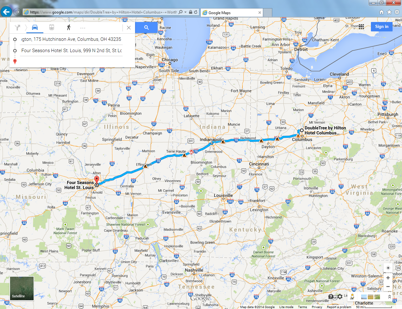
An Excellent Motorcycle Adventure! Day 3!

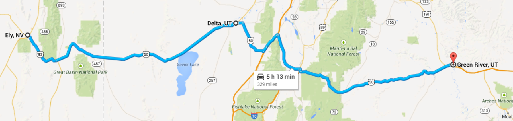
Columbus to St Louis
Columbus OH to Richmond IN
Today will be another long day of Interstate Highway driving. We are trying to make it to St Louis, MO by tonight, after that… we will proceed at a more leisurely pace.
There is a chance we will be dodging thunder storms again today, so we watch the television and utilize our ASTT devices[1], everything looks clear so off we go… an early start at 7:13 AM. We are a little confused as to how to find I-70 West. Downtown Columbus has undergone some urban renewal and someone thought it would be cute to pave all the east west streets with cobblestones.[2] This would be deadly on the motorcycle. So we keep driving around until we kind of discover a place where the Garmin GPS unit could direct us without using cobblestone streets.[3] Finally we are on our way.
Immediately, the skies are threatening and it is starting to rain. What’s up with that? The weather report and the ASTT sowed clear skies. We could have delayed our departure until it passed. Disappointing, but part of the world I guess. A lesson not to believe too much in technology. A lesson that when the rain gods want to rain a little, you’re gonna get wet. There is an exit about two miles ahead so we make for that, hopefully there will be a gas station with an awning we can park under while we wait for the storm to pass.
Just as we get to the exit, blue sky starts to break through, so we continue without stopping. My legs are pretty wet, and the windshield is covered with raindrops so it is hard to see. We spend the next hour drying out.
“… Rolls along passes houses, farms, and fields…”
From the song City of New Orleans
by Steve Goodman
This part of Ohio, west of Columbus, is all farms. In fact, it appears to be all corn. It looks to have been done in three plantings. In some of the fields the corn is about a two feet high; some fields are about a foot high; some have just been planted. I shout back to Ruth, “Wow! That’s a lot of corn!” Silly, I know, must it really was a lot of corn. I didn’t realize that it was only the beginning of the corn.
Obviously today, farming is highly mechanized. In the USA we have the lowest percentage of our labor force engaged in agriculture of any country in the world… and we manage not only to (basically[4]) feed ourselves, but we export food too. I’m looking at all of these fields, tens of thousands of acres, thousands of square miles and I’m thinking back to when this was all done without mechanization. It makes no sense that it could have been, at least to me.
Anyhow, I start humming the old Steve Goodman song City of New Orleans. I’m pretty hung up on the lyric about rolling along pass houses farms and fields.
When you are on a motorcycle, you have a lot of time to yourself… even if you have a passenger. The motorcycle environment is just not conducive to scintillating conversation.[5] You are essentially alone. So your mind wanders and you can think about all kind of things, not all of them world class thoughts or philosophy. Some of them pretty stupid. I had this idea that the motorcycle trip would enable me to clear out the cobwebs, reflect on life. I’ve had some challenges in the last year and I thought reflection would do me some good. Contemplation. Think big thoughts.
But instead, I find myself thinking about vehicle names.
In our family we are a little wacky in that we are one of those families that names our vehicles. It is a little embarrassing to admit it. I’m not sure how it really started. Our first car, a 1974 Ford Pinto wagon with Firestone 500 radials[6], was named “Bubby”… or “Bubs” for short. Our second car, a 1982 Mazda 626, was “Mona”. We had a long series of Volvo sedans: “Earl”, “Cousin Earl”, “Grandpa Earl”, etc. Ruth’s current car is “Lulu”. My current shitbox is “Bessie”.
Silly I know.
Anyway Ruth has been after me to name the motorcycle. Our previous motorcycle had a name, “Siggy”[7], but I have been resisting naming this one. She has been pretty persistent about it, and I have been pretty consistent about it. But, I have to admit that I just haven’t been able to come up with a good name.
Looking though, at all that corn, and all those houses, farms and fields… strikes me that I could name the motorcycle City of New Orleans. It’s perfect. That way I can sing “Riding on the city of New Orleans… rolls along pass houses farms and fields”. It is perfect. Of course I’ll have to rewrite a few lyrics to make it come out right. I’m not sure what to do with the old men in the club car. Or the mothers with their babes asleep, rocking to the gentle beat.
From there I start to think about names in general. Why does the bike even need a name? What about “The Bike with No Name”.
Richmond IN
We crossed into Indiana and immediately I stop thinking about names of motorcycles. There are two things going on. The first is that the road has become terrible, poorly maintained, bumpy, potholes, patches. In a car these are an annoyance, on a motorcycle they can be deadly. The second is that there are all of a suddenly all these wacky billboards.
I’m kind of surprised that the road is so bad. I normally don’t drive the motorcycle much on interstate highways, preferring back roads and country roads. We are only on the interstate because of time constraints. A bump or a pothole on a back road can be dealt with, there is usually not much traffic and speeds are slower. A bump or a pothole on the interstate at high speed is a major event.
The wacky billboards are interesting. There are a whole series of them advertising “Warm Glow” which we determine is some kind of candle outlet store. After a series of billboards, we figure out that they specialize in scented candles. After a few more billboards, I’m starting to think a candle or two would be nice to have along for the trip. You know… kind of romantic. The last billboard is the best. It turns out that Warm Glow is not just a candle outlet store. It’s like a destination rest stop too. A mini theme park of candles. A big tag line on the billboard claims: “THE CLEANEST RESTROOMS ON I-70”. Wow. It’s hard to pass that up.
Excitedly, I ask Ruth if she needs to go to the bathroom.[8] But she doesn’t so we travel on.
A Brush with an Alternate World
In some ways a motorcycle is more maneuverable than an automobile. It can swoop left and right. I can fit through small spaces. You can use the whole road when you are riding in a way that you just can’t when you are driving a car. You swoop and glide. It’s like skiing a little bit.
But you don’t make any sudden moves on a motorcycle. You can’t jerk the bike one way or the other. Especially not a big bike fully loaded at high speed.
We’ve have several occasions already on this trip, we can use the maneuverability of the bike to avoid obstacles and debris in the road. There are a lot of exploded tires out here on the interstates, apparently. They tend to show up well and we swoop right and left and avoid them.
Sometimes, though, they are harder to avoid. When the road is turning, or is banked, the motorcycle is more constrained. When the road is banking to the left, say on a downhill run, there is a kind of natural trajectory that the bike will need to follow. Again, the skiing analogy is appropriate. The speed of the bike and the direction, which can be normally be independent of each other, become coupled. For each possible line of travel there is a linked speed and angle. You just don’t change one or the other instantaneously, on the spur of the moment. If you do, you will find you have changed lanes (a bad idea in traffic) or gone off the road.
There have been a couple of times where there has been a small piece of debris in the road that I didn’t see until we were right upon it. It is too late to maneuver the bike in these instances, so you run over it and hope for the best.
The pothole comes at us from out of nowhere. The road surface is white concrete and the pothole is white and I just didn’t see it. It is too late to maneuver. The pothole is about 18 inches in diameter and about 8 inches deep.
All we can do is watch.
The bike passes right over the right edge of the pothole… the tires are literally hanging over the edge as we pass. We missed it by maybe an eighth of an inch.
I shout “WOW!” to Ruth. She replies “WOW!”
“THAT WAS BAD!”
“YEAH”
“VERY BAD!”
“YEAH!!!”
There are physicists right now working to reconcile our concepts of time and space with each other and with the precepts of quantum mechanics, which is the theory of how sub-atomic particles work. They’ve been having some success with these new theories (in that they can correctly predict the results of complicated experiments in large particle colliders), but the theories make the universe we live in much more complicated. In particular, we have to admit the existence of alternate worlds. At each instant of time, for each particle in the universe, many different things can happen. In these new theories, they all happen, each spawning a new, additional, alternate world that continues apace. The universe is constantly boiling with the creation of new, alternate universes.
Our encounter with the pothole was a glimpse, briefly, into these alternate worlds. Just an eighth of an inch more, a gust of wind, an unsteady hand on the handle bars, and… well I can imagine all kinds of alternate futures… none of them good.
We are silent for a long time after this.
Greenfield IN
The bike needs gas, and we need breakfast. We’ve come about 165 miles this morning, making pretty good time despite the obstacles. We pull off at Greenfield IN.
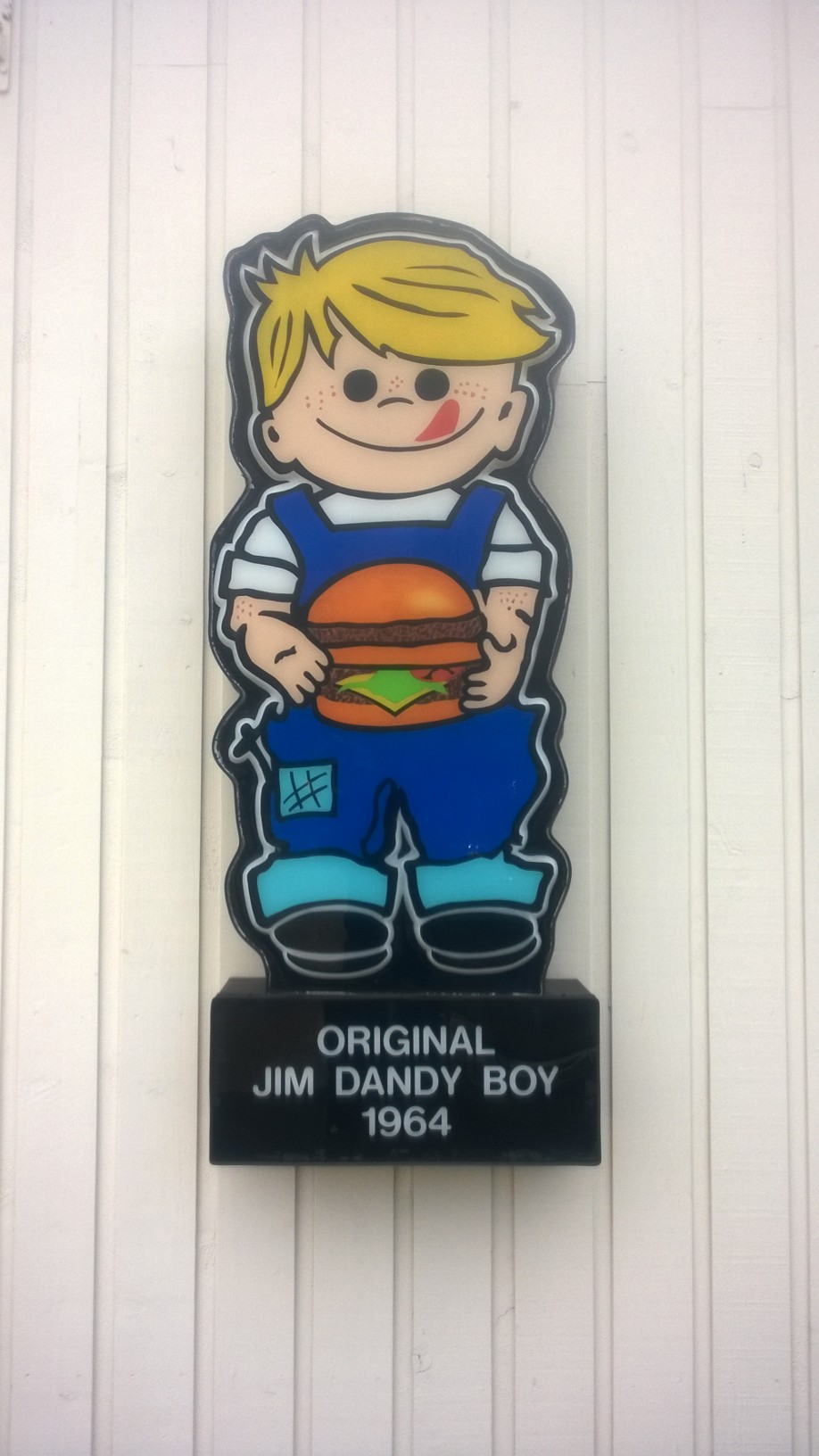
After yesterday’s experience Ruth is adamant about no more Waffle Houses, so while I gas up she walks across the street to see if the restaurant there is open and serving breakfast.
It is indeed open. It is called Jim Dandy’s and it is a family owned chain that has been serving this part of Indiana for fifty years. It is crowded, clean, the service is terrific and the food is good. Ruth is very pleased. I’m a little sad, because maybe it means no more Waffle Houses for me.

The Jim Dandy mascot. Jim Dandy has been serving central Indiana for fifty years. (c) 2014 Tim Carey
Greenfield IN to St Louis MO
The part of the journey is just a long slog. Grind it out.
We get through the maze of interstate interchanges in Indianapolis without mishap.
We pass through several more eternities of cornfields.
I think more about potholes and alternate worlds.
We cross into Illinois and stretch our legs at the rest stop in Marshall IL.
There are some more wacky billboards. Apparently the world’s largest wind chimes are in Casey IL. It must be a successful business, because they have a LOT of billboards. By the time we get there, I have read so much about the wind chimes (55 feet tall!) that I don’t have to see them anymore.
I‘m more intrigued by the world’s largest golf tee. They have plenty of billboards, but not so much information. They are much more mysterious. It’s a good strategy, I think… to create curiosity. But we don’t stop.
More corn.
Another sign that you can read about a quarter mile away: “Jesus has the Answer” in giant read letters. Like a smartass, I say to myself, “Yeah, but what’s the question?” When we get closer, I can read the rest of the sign: “Where will you spend eternity?”
Oooops.
Finally we gas up one last time in Edwardsville IL. It is really hot, about 95ͦ F. We are only about 30 miles from St. Louis.
Ruth has a treat for me in St. Louis. She has made a hotel reservation at the Four Seasons. Normally we catch-as-catch-can with hotels., not booking in advance. Tonight, though, we’ve been working hard for three days and she wants to treat me right. The Four Seasons is above the budget and over the top, but I’m really looking forward to it. All of a sudden, we are there. The St Louis skyline is ahead of us. We cross the MIGHTY MISSISSIPPI RIVER ITSELF on the Martin Luther King Jr Bridge. The famous St Louis arch is to the left, the hotel is to the right. We are at the gateway to the west.
We have arrived. It is terrific.
Summary
Date: June 25, 2014
Departure Location: 50 S Front St, Columbus, OH
Arrival Location: 999 N 2nd St., St Louis MO
Total Miles: 433
Total travel time: 9:08
Total miles/total travel time: 46 mph
Number of States: 4 (Ohio, Indiana, Illinois, Missouri)
Number of Watersheds: 1 (Mississippi River… mostly Ohio River Division)
Stops: 4 (Greenfield IN (gas, breakfast), Marshall IL (leg stretch), Edwardsville IL (gas), Ashland Ohio (gas))
Weather: Cloudy, Threatening Skies, Clearing, Partly Sunny AM, Cloudy PM, Threatening Skies, Scattered Showers PM
Temperature: 7:00 AM (Columbus OH) 68 ͦ F, 12:00 Noon (Indianapolis, IN) 85 ͦ F, 7:00 PM (St. Louis MO) 85 ͦ F
Lodging: Four Seasons, St Louis MO
Restaurants: Jim Dandy’s Greenfield, IN; Cielo, St Louis, MO
[1] ASTT is an acronym Advanced Storm Tracking Technology. As discussed previously, this is a cell phone with a Weather.com app.
[2] These are not your 21st century imitation cobblestone pavers, actually made of cast concrete. No, no, no… these are real granite cobblestones from the 19th century, probably salvaged when they were digging up the roads. I get the idea that cobblestones where the only practically paving technology 20 years ago, but they were brutal even then for horses and carriages. They are brutal even now to drive on in a car. You can’t even really walk on them very comfortably. I get the connection to the past aspect of using cobblestones, but really… these make no sense.
[3] I have an option on the Garmin to avoid dirt roads, but no option to avoid cobbles.
[4] I am not underestimating the hunger and poverty issues in our country,
[5] A typical motorcycle conversation: “Wow! Look at all the corn.”
“WHAT?”
“I SAID, LOOK AT ALL THE CORN!!”
“YEAH.”
“HOW DID THEY DO THIS BEFORE MECHANIZATION?”
“I DIDN’T GET THAT.”
“I SAID, HOW DID THEY DO THIS BEFORE MECHANIZATION?”
“BEFORE… WHAT? I CAN’T HEAR YOU”.
You get the idea.
[6] You remember, this was the car with the exploding gas tank in rear end collisions. And the Firestone 500 radials were recalled for manufacturing defects.
[7] Named for a character in John Irving’s Setting Free the Bears
[8] “Do you need to stop for a bathroom break?”
“WHAT?”
“I SAID, DO YOU NEED TO STOP FOR A BATHRROM BREAK?”
“NO, I’M FINE”.
“THAT CANDLE PLACE HAS THE CLEANEST BATHROOMS ON I-70!”
“WHAT?”