
An Excellent Motorcycle Adventure! Day 5!
Kansas City to Sioux City with Rain Delays
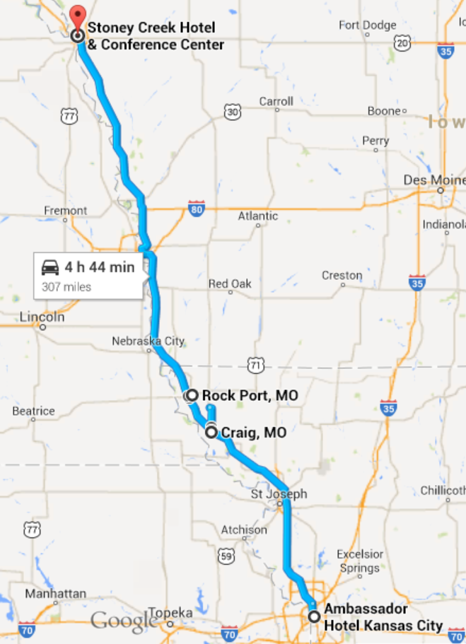
Kansas City to Sioux City
We have an easy day planned today, just 300 miles or so up to Sioux City. The first couple of hundred miles will bring us to Omaha, one of my favorite cities in the Midwest, and there are some Lewis and Clark sites to visit at Council Bluffs. I’m hoping to have a nice lunch in Omaha, as my research has not shown much fine dining in Sioux City for this evening.
We’re planning to use the interstate, I-29, for the first two thirds of the trip to Omaha, then take NE-75 North. NE-75 parallels the Missouri River for a good bit, so we are interested to see what the geography looks like in that part of the watershed. It looks less hilly, twisty and turny than the county roads we traveled in Missouri… so there shouldn’t be much challenge today at all. A nice relaxing day.
We depart Kansas City a little before 9:00 AM. The skies are overcast, but it is not too cold. You don’t have to get very far out of town before you are right back in rural America… more corn fields.[1] The land in this part of the country is surveyed into square mile sections, each with 640 acres. Dirt (or sometimes paved) roads separate the sections. Thirty-six sections make a township, at is common for all the roads in a township to be built on the same kind of a north-south-east-west grid. The interstate highway, or course, does not respect the grid at all. It goes where ever the federal highway designers thought that it should. I guess this an example of what we now call “Federal Government Overreach”. Roads are cut through by I-29 and they just dead end at the highway, and we can see them pick up again on the other side of the highway right of way… sometimes the power lines cross the highway to pick up the section road on the other side.[2]
We cruise along I-29 with the skies becoming darker and more ominous with each passing mile. We hadn’t been very diligent about checking our ASTT[3] because it was good weather in Kansas City and only about three hours to Omaha. But at about halfway, things are starting to look very ominous indeed. We watch carefully for drivers with their window wipers on the southbound side of the highway. Sure enough, we see a few window wipers and we feel our first big drops of rain.
The road sign at the side of the highway indicates an exit in two miles, for Craig MO. Big drops are still coming down, but no deluge yet, we make the exit and turn left… following signs for a Sinclair Station.[4] We pull into the Sinclair station (there is no garage, but there is a convenience store) and are under the canopy at the gas pumps when the deluge begins.
We decide to fill up with gas, although we really don’t need any, just so that it seems like we aren’t completely poaching. There is another motorcycle here, they are putting on their rain suits and we decide to do the same. They don’t seem in the mood to chat, and they soon pull out. Ruth goes into the convenience store and comes out with bottled water and some maps.[5]
She remarks that the people inside didn’t seem too friendly.
Just then, a big BOOM, CRASH of thunder and lightning and we know that we aren’t going anywhere for awhile. We stand around under the canopy and try to “enjoy” all of this as best we can. We are getting sporadic updates on the ASTT… dependent on signal strength. The storm is moving NE, which means if we want to avoid it we need to head west… and try to get around underneath it.
Ruth studies the maps and comes up with a genius idea, at least I think it is genius. She is more modest about it. She has determined that the side road we are on, MO-59, continues north and in about seven miles connects with a route that will take us west, hopefully around the storm. All we have to do now is wait for the rain to stop… which is does presently… in about 45 minutes.[6]
Finally a break in the rain. We wait about another ten minutes until we are sure that there is no more thunder and lightning, and then we are off.
It turns out that Ruth’s modesty about her route was well placed. In order of occurrence:
- It starts to pour again in about two miles.
- It starts to thunder and lightning again
- This country road is narrow, poorly paved, with no shoulders and a 65 mph speed limit
- This country road, which we hoped would be idyllic, if somewhat wet, is the main truck route to Fairfield MO. I am driving somewhat slowly due to poor visibility from the rain
- The combination of 4 & 5 means I quickly pick up a caravan of irate tractor-trailer truckers behind me.
I pull off onto a dirt road and we decide to wait for the rain to end again…
Fortunately our spiffy rain suits keep us dry and after awhile the rain stops again. Unfortunately, this dirt road is not the best surface on which to muscle the bike around as I try to maneuver it back onto MO-59. The bike, fully loaded with me, Ruth, and luggage weighs about 1350 lbs. I have Ruth get off and she has to help push as we manually perform a three-point turn. Meanwhile, the big tractor-trailers are passing by at 70 mph… amused, I hope.
We decide that the interstate highway will be safer… the two lanes means that I can drive slowly and the trucks and other traffic can pass… and the extra traffic will help dry the road out sooner, improving traction.
So, with our collective tails between our legs again[7] we get back on the interstate.
We have to stop again in Rockport MO, just before the Iowa border. We manage to do this at a fully equipped truck stop, which means we can get snacks and a drink and that our ASTT devices have good connections. We receive weather warnings: “WARNING LOCAL FLOODING IN BROWNSVILLE”, about 5 miles away… “WARNING HEAVY RAINS WEST OF OMAHA”, about 70 miles away… “WARNING HEAVY RAINS AND LOCAL FLOODING…”, well… you get the idea.
After awhile the rain stops and we can resume our trip north, We give up on Council Bluffs, we give up on lunch in Omaha, we give up on the idyllic route NE-75. We just go up I-29. We do manage to pass by the burial place of Sargeant Charles Floyd, the only person to die on the Lewis and Clark Expedition. We arrive in Sioux City where Ruth has selected from the available assortment of IHLCs[8]
The restaurant choices, as I feared, are indeed unmemorable.
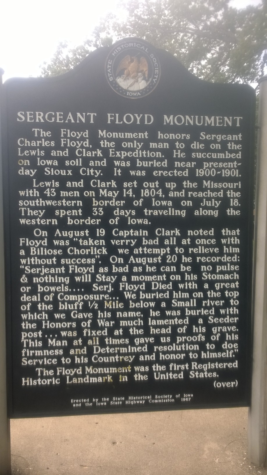
Sergeant Charles Floyd Memorial, Sioux City Iowa (c) 2014 Tim Carey
Summary
Date: June 26, 2014
Departure Location: 1111 Grand St., Kansas City MO
Arrival Location: 300 3rd St. Sioux City IA
Total Miles: 297
Total travel time: 9:57
Total miles/total travel time: 30 mph
Number of States: 2 (Missouri, Iowa)
Number of Watersheds: 1 (Mississippi River… Missouri River Division)
Stops: 2 (Craig MO (gas, rain delay), Rockport (rain delay))
Weather: Partly Cloudy AM, Thunderstorms PM
Temperature: 7:00 AM (Kansas City) 75 ͦ F, 12:00 Noon (Craig MO) 71 ͦ F, 7:00 PM (Sioux City IA) 73 ͦ F
Lodging: Stone Creek Inn, Sioux City IA
Restaurants: Luciano’s, Sioux City IA
——————————————————————————-
[1] As I have mentioned before, these cornfields, tens of thousands of square miles have been driving me crazy. How did they possible develop all of this in the 19th century? I have since done some research. The first mechanical planters (horse drawn) were invented and developed in 1701 by Jethro Tull. The first mechanical reapers and thresher was developed by Cyrus McCormick in 1831, The first mechanical reaper/thresher was also invented by McCormck in 1847. So I guess the answer is that agriculture in the Midwest was enabled by mechanization right along.
[2] When I was a boy, I lived on a short dead end street that had been cut-off in just this way by the construction of the F.E. Everett turnpike in Nashua NH. I could stand at the fence at the edge of the highway right of way and see the continuation of my road on the other side. I wondered where the road went and if there were people over there… I was maybe six or seven years old. When I got older, maybe ten or twelve, I would take my bicycle across the highway and try to find the continuation of my street, without much success.
[3] Advanced Storm Tracking Technology… this is a cellphone with the weather.com app (see previous posts for a complete description).
[4] Howis the Sinclair Gasoline Dinosaur Logo still relevant? They need some market research and focus groups to come up with a new logo, yes?
[5] This is a good time for a confession, a confession that I have already made to Ruth. I ordered a set of 26 Rand McNally road maps, for every conceivable route that we could take before we left Cambridge. Where are they? On my desk. Somehow my packing process wasn’t very robust, I guess.
[6] This is going to trash our daily “total mpg” metric.
[7] See Day 4 for another instance of the roads being better that me
[8] Interstate Highway Lodging Choices: Days Inn, Comfort Inn, Hampton Inn, etc., etc.,

all caught up….loving it!
Not surprised…have been following the weather channel…the whole country is under segue, except here…stay safe..